Sunday, December 27, 2015

When the Market Built Housing for the Low Income

In a recent post, Daniel Kay Hertz examines residential filtering, the process by which housing units depreciate and therefore become available to lower-income buyers or renters over time.  In particular, Hertz examines a Stuart Rosenthal article on the phenomenon which I have examined critically here and here. Although he makes the very good point that the filtering process is not operating in unhindered fashion in many large American metros, he also makes the claim, which I have seen in many other contexts and by other authors, that "very little private housing in the United States was originally built for low-income people."

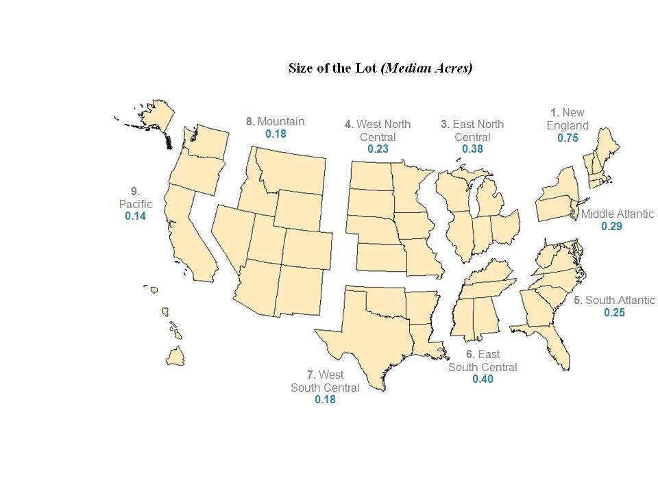
Although this may be somewhat accurate so far as it only applies to formal housing developers, throughout the history of American cities and indeed most other cities in the world, a large portion of the housing stock came from the informal economy, most of it purpose-built for indigent migrants or very poor laborers.  This was the case even in some of the largest and wealthiest cities in the Western world until fairly recently.

In the typical city, such housing would (and is) either be found on the outskirts or on very low-value urban sites, such as floodplains, rocky ground or steep slopes.  Infrastructure was poor and public services were minimal or nonexistent.

American Favela: The "Dutch Hill" area of midtown Manhattan in 1863.  Source here.
Rather than filtering down, these rudimentary settlements had and have a tendency to "filter up" internally, as residents gained a foothold economically and improved their dwellings.  For most Americans, the best-known of these types of areas are the so-called "Hoovervilles" of the Depression era, when the unemployed and rural migrants occupied low-value or underused land near city centers:

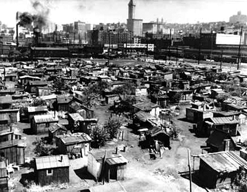
Seattle, WA in the 1930s. Source.
These crude shacks offered little more than shelter from the elements, but they were the result of people in dire situations doing the best they could with what they had available.  Governments then and now refused to accept this reality and, rather than trying to improve the conditions within these settlements, generally favored mass eviction and demolition.  In an interesting twist, this style of development has been rediscovered by contemporary American cities (particularly Seattle), and, without apparent irony, has been rebranded as the "tiny house village."

Beyond housing for the very poorest of the poor, American cities through at least the 1920s built in bulk for the lower end of the income scale.  This housing took several forms:
  • As noted above, shanty housing built by those with little or no experience in construction.
  • Small, temporary and/or transient housing, such as flophouses, boarding houses and other manner of SRO rentals.
  • Small multifamily housing wherein a person of some means would build a home with one or two attached apartments which could be let out at low cost.  Often these apartments would be sub-let to boarders who might occupy a single bedroom.
  • Self-built housing of a higher quality, which might be built from a Sears housing kit, or by a person with some background in construction.  One study estimates as many as 1 in 5 American homes were self-built in the 1920s.
  • As noted in the comments, company towns and other housing built by large businesses for their workers to inhabit. 
The first, second and third of these options were virtually outlawed starting in the 1920s and in the decades following.  What changed during and after the 1920s was not the market's willingness or ability to continue constructing such housing, but society's tolerance for housing of perceived low quality or of profitable use.   The Housing Act of 1937, for instance, was not so much concerned with ensuring affordable housing for the poor, but rather with "the provision of decent, safe and sanitary dwellings for families of low income and the eradication of slums."  Single-room rentals did not fit into this well-meaning but upper middle-class vision.

The "eradication of slums" element of this strategy was more faithfully carried out then the provision of dwellings, and in the process much of the evidence of the low-income neighborhoods of the pre-1950 period was obliterated.  Municipal archives may contain photographic documentation of the condemned neighborhoods, as in the case of Nashville, below, showing a street of tin-roofed shotgun houses and very modest bungalows built in the early 20th century for lower-income tenants.  All were "eradicated" in the 1960s along with much of the surrounding neighborhood and their residents dispersed elsewhere.  That many of these neighborhoods were demolished or saw demand for them fall to near zero, with resultant abandonment, should not cause us to forget they ever existed.

Nashville houses circa 1960; all demolished in urban renewal.  Courtesy MDHA.
It might not be going to far to say that the traumatic process of urban renewal instigated an involuntary filtering, as residents of the poorest areas were literally displaced -- cast out of condemned homes -- and forced to seek new housing from among a diminished housing stock.  These people probably did move into somewhat higher-quality housing, but at higher cost and possibly in more crowded conditions as well.

But what of the fourth type of housing, the proper self-built house?  As it turns out, there was a crackdown on this type of housing as well for reasons that seem to have had less to do with ensuring decent and sanitary housing and more to do with disreputable and exclusionary motives.  The impetus for these changes may have been the mobility provided by the automobile.  I'll quote from one book at length which describes one town's legislative action against black self-builders in Ohio, including one Eddie Strickland:
"In 1946 ... in a series of irregular meetings, the council [of the town of Woodmere, Ohio] passed a building code aimed at restricting do-it-yourself builders, among whom blacks were a prominent group. The code mandated a maximum one-year time limit for the construction of new homes, forbade secession of work for any period longer than forty-eight hours, and prohibited the use of secondhand building materials. Finally, the code required builders to post a $1,000 bond to ensure compliance..... 
"By lifting construction standards (and allegedly enforcing regulations in a discriminatory manner), Woodmere officials raised the cost of home building in the village and substantially limited settlement by working-class blacks. Moreover, the passage of similar building restrictions throughout the county helped limit the number of African American suburbanites in the Cleveland area. The trend had an apparently chilling effect on the attendance of blacks at the weekly land auction in Cleveland, where a number of families had formerly purchased suburban land for delinquent taxes.... 
"Far from being an isolated event, Strickland's confrontation with authorities in Woodmere reflected a national trend toward regulation of the suburban fringe that hastened the decline of working-class suburbanization in the postwar decades. In Cleveland and other metropolitan areas, the proliferation of suburban municipalities led to the extension of land-use regulations to formerly unregulated areas. Zoning and building codes curtailed informal home building and inflated the cost of a suburban home. Racist application of these regulations closed the door on development for blacks, and the enforcement of sanitary regulations led to the demolition of existing black housing and restrictions on domestic production. 
Excerpt from Places of Their Own: African American Suburbanization in the Twentieth Century by Andrew Wiese
Disputes over self-built homes continue to arise today in remoter regions, as seen in the recent lawsuit brought on behalf of Amish homebuilders in upstate New York who were being required by local codes to submit architectural plans and install other expensive features in their self-built farmhouses.  The elimination of the self-built home as an affordable option in much of the country, in conjunction with zoning regulations limiting small multifamily housing, setting minimum lot sizes and imposing other similar restrictions, completed the elimination of the lower rung of prior housing options.  Left were only the newer mobile/prefab home, which partly stepped in to fill the gap that had been left, and the filtering process, which though demonstrably effective was not always rapid enough to insure a sufficient quantity of housing nor sufficiently cheap housing, especially in cities with high residential demand.

Of these two options, mobile homes were heavily restricted in where they could be located, and urban renewal destroyed huge quantities of filtered housing, i.e., "blighted" homes.  The result is a market which appears, artificially, not to create low-income housing options.

Is this article a call for the return of flophouses, then?  Not in the sense of the negative and unsanitary associations of that term and other like it, but in the sense of a government which recognizes that these older types of housing represent the market's effort to meet vital needs, and that regulation can help meet these needs in a safe and sanitary way without taking an adversarial approach toward them.  These market approaches can be complementary to public housing investments and other public assistance programs, as well, rather than being seen as inferior alternatives.  The tiny house village movement mentioned earlier is one such manifestation of this approach, and shows that the political obstacles need not be insurmountable.

Other and related reading:

Friday, December 25, 2015

That 70s Urbanism, Part II: Fixing Urban Renewal

On Twitter, Cap'n Transit appreciated my focus on Stamford in the previous post, so to continue on the prior topic with an ongoing focus on the 1970s, I'll return to that city to offer some perspective on the past as well as some ideas for the future.

Best known as an office escape for New York-based banks and other companies, the city actually has a history nearly as old as New York itself and, before urban renewal, had a street pattern as intricate as lower Manhattan's old Dutch footways.  The New York and New Haven railroad cleaved the town in the late 1840s, and in the part south of the tracks polluting factories cropped up along the waterfront and canal.  In the 1950s, Interstate 95 ripped another path through the heart of the city, though partly following the railroad right-of-way.

Stamford's downtown in the midst of renewal, 1979. City of Stamford via Ferguson Library.
Finally, a massive urban renewal project, initiated in the 1950s but only carried out in full in the 1970s, destroyed the bulk of the city's downtown area and resulted in the demapping of many streets, even including the primary stretch of Stamford's Main Street.  These streets were replaced by high-speed "stroads," and the office buildings that replaced the fine-grained fabric of the city took the form of glass and granite monoliths perched over parking lots, serving as fortresses against the miasma presumably thought to be swirling on the near-empty sidewalks.  A large enclosed three-anchor mall was constructed over several blocks of condemned buildings.

Reworking 1970s Urban Renewal

The age of massive urban renewal on the scale that Stamford pursued is over, by and large, some planning projects in Baltimore excepted.  Stamford is unlikely to ever engage in another project of such scope.  As I noted in the previous post, however, a city like Stamford can still use those elements of 1960s and 1970s planning to its advantage if it plays its cards correctly.

The 1970s as I wrote were an early golden age of pedestrian infrastructure as reflected by several key elements which are broadly applicable to today's cause of walkability, although not all are today well-regarded:
  • Mass transit (obviously - the 70s witnessing a revival of heavy rail systems)
  • Generous use of elevators in public space
  • Escalators and moving walkways
  • Pedestrian tunnels, skyways and covered sidewalks
  • Pedestrianized streets
  • Enclosed malls and other shopping areas
In addition to the above, Stamford has in the last 20 years enjoyed a resurgence of the "Euro block" apartment form throughout the downtown area, in addition to an earlier boom in townhouse-over-garage condominium construction.  Although Stamford will not be Barcelona anytime soon, good things can be and should be happening, but the downtown is as car-dominated as ever.  How about a plan for incremental improvement?

The plan I put forward has several components, some inspired by Jane Jacobs, some by Jeff Speck, some by Nathan Lewis and Japanese city planning, and by others too numerous to mention:
  1. Extend the enclosed shopping area in the train station
  2. Narrow several of the downtown streets by sidewalk widening and use of bike lanes
  3. Use eminent domain and existing public land to open several new narrow streets
  4. Provide arcaded pedestrian streets where appropriate
  5. Open the mall to the street and re-open Main Street
  6. Use the under-capacity mall and Target parking lots for long-term parking for downtown residents in lieu of parking requirements
In most cases, new streets are built on existing public land and would require little or no condemnation.  Some simply represent streets which were uprooted and de-mapped during urban renewal.  Most vital to these is the continuation of narrow Summer Street down to the UBS building.  The street narrows to only about 16 feet at its southern extremity, and should be continued at that width further south, ideally as a shared space or even pedestrianized shopping street that will provide a safe and attractive walking path from the train station (a moving walkway probably veers too far into parody/Seinfeld territory).  As a 16' street, it could possibly be arcaded as well.  The street would terminate at the UBS building into an existing pedestrian pathway that leads to the train station.

This image, rotated counterclockwise, shows how the new street would appear lined by Euro block apartments and shops, leading with only a couple of curved turns directly to the train station, which has an existing underpass lined with a few shops passing underneath I-95.  This line of shops would be carried across past I-95 and along the path in front of the UBS building, possibly incorporating an anchor store:


Patching Up the Mall

In the previous post, I showed one way the mall could be opened to the street by demolishing one of the car access ramps:

At present, left, and after new entrance.
Additionally, entrances could be punched into the mall at various other points on the exterior, as most parking is actually above the mall, and shopping can be accessed at most points directly from the street.

Narrowing Other Streets

Atlantic Street, onto which this mall entrance faces, should be narrowed from three to two lanes throughout its length with a bike lane added.  A shared space arrangement with bollards (bollards inside the bike lane) would be an ideal treatment.  A new street of 16' or so (not shown) should be run past the facades of these buildings, through the adjacent park, under the mall and into the remnant stub of the old Main Street.  Half of the overly-large park (really a paved square) should be sold off to private parties to construct new buildings along the southern boundary of this new street, leaving a still-large triangular square bounded on all sides by rights-of-way.  

The city should also use its power of eminent domain to open new streets and to complete those discontinuous fragments that already exist.  The below map shows existing streets in red, pedestrian paths in orange, and suggested new streets in yellow:


These new streets also include a pedestrian bridge over Mill River at the upper left, the new 16' street referenced before curving through the park, a new arcaded street through the mall, and two streets creating a three-part division of a large, partly unbuilt block at the right.  Other segments have been added here and there, and the continuation of Summer Street is visible in the center right.

Transportation

Regarding transportation, despite the likely high cost, it may be desirable to create a second stop in downtown Stamford at either Canal or Elm Streets or along East Main Street.  This would help convert the train system into a small localized rapid transit system, and has parallels elsewhere on the line with New Haven's State Street station, Bridgeport's planned second Barnum station and Fairfield's Metro station.  

A full infill station, complete with station house, was built in West Haven for $80 million, though the Bridgeport's station's cost appears to be nearly double that.  Since Stamford is the last stop for many express trains, it would not unduly interfere with express train operation.  An Elm Street or East Main Street station serving the Cove neighborhood and providing a secondary downtown route might be very popular and would not require much parking.  There is ample room for it, and the existing overpasses dating from the turn of the century, will need to be replaced sooner or later.


Optimistically, a plan like this would have a ten-year time-frame from initiation of planning to start of operation.

Parking

Parking is always one of the thorniest issues in downtown planning, but Stamford, for better or worse, is "blessed" with an abundant supply of garage parking.  In particular, the mall parking lot and the Target parking lot are greatly under-used.  In light of this parking supply, if parking minimums cannot be abolished entirely, the city should offer fee in lieu of parking to any residential developer who secures a parking arrangement with one of these local operators.  The number of spaces required to be secured should be as low as politically feasible.

It goes without saying that on-street parking rates should be dramatically increased in the downtown area.  The city is currently attempting to raise additional revenue by imposing new fees on outdoor dining spaces, yet the parking adjacent to it continues to be greatly underpriced.  Although I am generally opposed to on-street parking in areas with high pedestrian volumes, a Shoup-inspired approach that used increased fees for civic improvements could be a positive change.

What Not to Do

Stamford is currently undergoing a major redevelopment project in the Harbor Point area, a former mixed industrial and residential area in the South End of the city, west of the canal.  Although purportedly the handiwork of planners, the haphazard arrangement of streets and commercial spaces creates an environment which at best, is reasonably pleasant, but which at worst is less than the sum of its parts.  

Here are some examples of the decent, the bad and the ugly.  One of the newest areas features a semi-shared space street (interesting) with use of bollards (good), yet the space is overly large (not good) the architecture is completely cold and indifferent (not good) and the scene is altogether too busy with too many plantings (not good).  There are a couple of restaurants along the street to the left with outdoor seating, which greatly helps to enliven the area in the warmer months.


For contrast, here is a street in between two apartments, lined with garages and electric equipment.  This is an unpleasant and even dangerous street to walk down, and it is right off the main park square!


Most unforgivably, in another area close by, is this facade on the local neighborhood commercial main street.  I generally try to steer away from strong language so that readers may make up their own minds, but this is simply atrocious.  The street level must be done better than this.


There are many other changes large and small that one could consider throughout Stamford as a whole, and the city does seem to be engaged in a process of gradually narrowing intersections by bumping out sidewalks, thereby improving pedestrian safety.  With several recent and well-publicized deaths of pedestrians, this needs to be an immediate focus and priority.  Zoning needs to be reformed as well, but that is a post that I have already written.

Monday, December 21, 2015

That 70s Urbanism

1970s suburb, Birmingham, AL.
The 70s, as much as any decade from the 1920s to the 1990s, has gotten a bad rap in contemporary urban planning circles.  It was the golden age of the suburb and the nadir for many urban areas around the United States, not to mention a boom time for highway construction and the development of very low density suburbs on non-gridded street patterns.  Surely there is nothing we can glean from this time period that has applicability to the urbanism of today?

Well, this is perhaps not entirely true.  The 1970s, as well as the decade before it, arguably represented the first time in the urban history of America that planners self-consciously pursued entirely pedestrianized environments, although the inspiration for these areas went back to flights of imagination from the 1920s if not earlier, and the 1950s saw the genesis of several of these ideas, at least in their embryonic forms.    I refer not only to pedestrianized main streets, but to the five great pedestrian creations of the age: the enclosed shopping mall, the international airport, the vacation resort, the convention center, and the network of tunnels and/or skyways.  Each of these represented a vision, if incomplete, for pedestrian-only circulation and commerce on a grand scale, often on the footprint of a small town.  

Do I jest?  No.  The future, if the human imagination is a key to the future, was pointing toward pedestrianism in the 1960s and especially 1970s.  This was, after all, the age of Paulo Soleri's implicitly pedestrian-centric arcology.  Gas prices were soaring by the early 70s.  The 1939 World's Fair vision of high-speed highways was out, and a more refined tecnho-utopianism involving futuristic megastructures was in.  The great majority of the buying public rejected this vision for their private lives, but as the success of enclosed malls shows, they gladly embraced it in many other contexts -- in commerce, for employment, in travel and for recreation.  

The arcology: no highways here, or at least, not the central element! Source.
The tunnel system of Houston and the skyway system of Minneapolis, both begun in earnest in the 1960s, were built out through the 1970s.  Enclosed mall construction, which began in 1956, was in such a boom that four enclosed malls opened from 1969 to 1980 in the city of Toledo, Ohio alone.  Air travel multiplied through the 1960s and airports were expanded on an unprecedented scale.  The very idea of the convention center, although it had been around for decades, attained gargantuan scale by the latter half of the 20th century.  

The hostility toward these type of environments in recent years, has, it seems to me, been based on two primary grounds: 1) the environments, being private and privately controlled, are corporate and sterile; and 2) although the environments themselves may be pedestrian, they are dependent for their business on car-driving customers.  Of these two critiques, however, the second is not inherent to the form of the structures themselves.  Rather, a pedestrian environment such as a tunnel system or an enclosed mall is, as the cities of Japan or Korea bear witness, a better partner to transit and walking trips than it is to car transport.  That the United States largely squandered its opportunities to integrate these structures and systems into its transit networks is an indictment of city planning, but not necessarily of these forms themselves.  

The Japanese, arguably the best city-builders in the world, have not missed this point, and typically have built shopping malls either adjacent to or, in the case below, on top of railway stations:

Osaka's Keihan Mall, over the Kyobashi railway station. Bing Maps.
In the case of American cities, even where the option is obvious and available, no such plans are made.  In Stamford, Connecticut, where nearly the entire downtown was condemned and bulldozed in a vast urban renewal scheme, the new enclosed mall built by the city's hand-picked developer was inexplicably not located next to the city's heavily-used Metro North railway stop:

The mall, at top right, and station, at bottom left.  Bing Maps.
What were they thinking, one could ask.  Note also the very low value placement of the interstate highway just north of the railway line, although this area probably had higher property values than the south side of the tracks at the time of the highway's construction.  In truth, the Stamford planners had given up entirely on any idea of pedestrian circulation outside the new megablocks.  The curated spaces within the new mall were designed to be accessed by car alone, and the structure to this day presents a fortress-like appearance to the outside.  The decision cannot even be explained by a desire to exclude train riders, who then and now tend to be well-heeled commuters to New York and are in general better off than most.

Had the planners of the 1970s left the city alone, and simply redeveloped the train station as a mall, who knows what might have happened by today?  Yet these questions need not be hypotheticals.  Cities have the power to make these changes today.  Stamford cannot move its mall, but it can consider a new infill station closer to it.  It can consider how to improve pedestrian mobility.  It can revamp its bus network.  It can do many things to address past mistakes, but it must be able to understand its mistakes, and even more importantly understand how these creations of the 1960s and 1970s can be a force for good, not merely magnets for a car-driving public.

There are a few easy steps that can be taken at first.  If Stamford wants to fix its mall, tear down one of the car ramp entrances, already duplicated by two others, and install a prominent pedestrian entrance, like so:


Easy?  In the grand scheme of things, yes.  Expensive?  Not terribly.  A bolder step would be an entirely new infill station, one closer to the mall, perhaps at one of the locations highlighted with a green arrow:


Plan a new station.  New Haven already did it, twice, and Bridgeport is doing it, so this need not be some impossible fantasy.  The overpasses need to be replaced anyways, so merge the projects.  Use the gains in real estate value to improve pedestrian connections.  Narrow the streets.  Add bike lanes.  It need not be that difficult!

If hostility toward the idea of enclosed malls, or skyway systems, or convention centers is retained, however, then cities may or may not succeed at revitalization, but they will squander again an opportunity to use these forces for good rather than ill.

---------------

Other reading:

See Mallville by Andrew Price for a related perspective on the traditional city aspects of the American mall.

Saturday, December 19, 2015

The Old(er) Way of City Planning

I've been reading through the 1912 "Plan of the City of Hartford" by the legendary firm Carrère and Hastings, a document which encapsulates some of the best conventional wisdom of that or any era in terms of planning, but which also foreshadows some of the profession's darker moments later in the century.
An ambitious comparison: Saxony's Dresden
as model for Hartford, CT's Capitol area.

There are many noteworthy aspects of the report, most prominently the heavy influence of European
laws and physical plans, and in particular plans of the cities of the German and Austrian Empires, an influence which would permanently fade after 1914.  Many of the cities featured in photographs as models for American cities to be followed were, only three decades later, obliterated in bombing campaigns, resulting in a physical destruction to complement the ideological and academic shifts in focus.

Although the laws of foreign countries provide as much to learn from as ever, as highlighted in Sonia Hirt's latest book, the report is significant to me for its focus on what was once called the street plan, a plan of such antiquity that it preceded zoning plans by millennia, going back to the Romans and further, and which was famously employed by American planners in such cities as New York, Savannah and Washington, D.C.  Rediscovering these plans has been a research focus of planner Paul Knight, who has devoted a website to the subject (I highly recommend his presentation on the subject, along with co-contributors available in PDF here).

The street plan, in antiquity and down nearly to the present day, was considered part and parcel of infrastructure along with sewer needs, fresh water and other necessities.  Not only major arteries, such as the old Roman inter-city roads, were considered as an object of central planning, but minor residential streets as well.  The 1912 plan explains the main rationale for this apparent micro-management as follows:


Reasonable enough?  One can read evidence of the practice of street development in the municipal proceedings of the era in a time before the existence of subdivision regulations, here as it turns out from Hartford's own Common Council Board in August, 1912:

In other words, while the developer would propose a street alignment, this was considered by the city planners in the context of the city plan itself, which at the time would have included a street plan.  Thus, for a developer to obtain approval of his proposed street, it would likely be to his benefit to have it agree with the city's pre-existing plan.  Thomaston Street, which exists today, fits seamlessly into Hartford's irregular, but generally continuous and interconnected, street pattern.  The street would also be a public one, but the plan was in conformity with the city's own plan for growth, and with such extensions happening incrementally, the city was unlikely to be overburdened with long-term maintenance obligations by such a development process.  Note also that Mr. Thomas named the street after himself, or so it seems -- apparently naming rights were vested in the developer, as a sort of added incentive.

Paul Knight's illustration of street-plan led vs. zoning led urban development.
But what of Carrère and Hastings' own plans?  A picture is worth a thousand words in this context, and fortunately the authors left us with some detailed renderings for street grid expansions.  Here the city "general plan," which as can be seen is a street plan, is presented in its entirety:


There is no zoning here, and no historic preservation overlay, although the heights of buildings were automatically limited relative to street width.  Notably are the large ring boulevard, cast as the Ringstrasse or Unter Den Linden of Hartford, but which equally appears to anticipate a grade-separated highway encircling the city.  Overall, the map delineates the public realm of the city: the streets, parks and certain public buildings, those things which were considered appropriate objects for planning.

Note also the newer planned areas to the corners of the map.  In contrast to the irregular grid of existing Hartford, these areas are drawn in a style which is clearly influenced by German neo-medievalist planning fashions of the day, but which again are also anticipating the curvilinear, limited access suburban developments of the late 20th century.  Nonetheless, the areas are drawn in in complete detail, with all, or at least most, subsidiary streets represented.

The planners note that Hartford was undergoing a period of small multifamily development, but are disappointed at the limited options for ownership under current laws.  One wonders whether they had pondered a condominium style of ownership, which at the time was still many years in the future.  In the absence of such laws, the only realistic option was for the freestanding house (common in Hartford) or the rowhouse (very uncommon in the city).

--------

What is sobering to realize from the vantage point of a century later is how utterly the City Beautiful movement, as represented by this crowning document, failed in its efforts to ape the grandeur of the European city, and how thoroughly it succeeded in anticipating the primacy of the car and the rash of road-widenings and "stroad" construction that would follow in its wake.  After 1914, in fact, much of even the desire for inhuman-scale grandeur would fade, to be replaced by cold engineering and mechanical precision.  Dresden was never again to appear as a serious model for Hartford or, most likely, any other American city, and certainly not after 1945.*  And the street plan?  It was eliminated, either folded into "comprehensive plans" or dissolved into subdivision regulations that, using 1930s FHA standards, encouraged the excessively wide streets that the Hartford planners warned of.  In most cities, only the zoning plan survives, with no separate street plan at all.  Streets, many of them private, take selfish, non-connected forms, with the result that greater and greater volumes of traffic are channeled onto fewer and fewer roads which must therefore take on ever-increasing dimensions to handle the load.

In a few fast-growing American and Canadian cities, such as Toronto and Dallas, something of a street-plan led growth pattern is visible, and in most Mexican cities such a process continues today.  But in other cities, there still may be something to take away from these old plans despite their failures.

---------

*Dresden's historic center is currently undergoing a major rebuilding project, indicating that Dresden may be built again, from scratch, before the original City Beautiful plans are fully realized in Hartford.

Saturday, December 12, 2015

Lot Sizes: Regional Trends and Causes

In a prior post, I examined minimum lot sizes as a general concept with reference to a few examples.  Another way of approaching the subject is to examine regional and national patterns and trends on lot sizes.  Although the subject doesn't get a great deal of attention, and Census information is not as detailed as one might like, it is possible to cobble together some statistics.

Based on data from the MLS as compiled by Realtor.com, here is a map showing the median lot size of properties offered for sale in each state (for 2012).  As we'd might guess, the patterns reflect both complex historical influences as well as current degree of urbanization:


More relevant to current debates over urban expansion and development are the median lot sizes of new homes, as compiled by the Census.  Unfortunately, the data is not broken out by state, but the regional trends are nonetheless interesting and helpful:

Source
As far as I can tell, rather than primarily being the product of planning and development policies, these differences are substantially driven by agricultural land values as well as groundwater availability.  Federal land ownership may also play a role in some western states.  A map of well-water supply is below, showing a fairly good correlation with lot size:

Source
The outlier value for New England in the median lot size map seems to fit the well-known historical account of agriculture in that region, where after the arrival of railroads carrying midwestern grain in the later 19th century, farms were rendered unprofitable and were abandoned en masse, leaving only stone walls -- 250,000 miles worth -- through new-growth forests as a sign of their former presence.  During the height of this abandonment in the 1890s, some New England counties, like Tolland County in Connecticut or Rutland County in Vermont, actually declined in population.   Post-1950 tract homes in New England, built in forested, rocky terrain, prefer to sit Walden-like in their own little forest clearings, as though each homeowner were an 18th century pioneer carving out a homestead in the wilderness.  Much of New England, as William Fischel also notes in Zoning Rules!, with a wet and cool climate, is heavily well-watered, with the result that homes need not be clustered closely together.

Outer suburbs of Hartford, CT.
Where agriculture yields the highest-value crops on a per-acre basis, such as in the fruit groves and orchards of Florida or California, the smallest lot sizes are found.  A list of the densest urban areas in the United States is surprisingly dominated by small California cities, such as Davis, Woodland and Delano, most of which sit within the fertile farmland of the Central Valley.  In Florida, meanwhile, the rapid development of The Villages retirement community has produced some of the densest single-family subdivisions in the entire country:

The Villages: homes built for former residents of Hartford, CT.
This ingenious map shows the distribution of cropland and pasture by type throughout the US, highlighting the concentration of agriculture in certain areas and its near-absence from wide swaths of the country, including the majority of New England, much of the southeast apart from coastal lowlands and the mountain and desert west:

Map by Bill Rankin.
In most of Europe and Asia, by contrast, pre-industrial towns and cities of necessity grew in immediate proximity to valuable agricultural land:

Farm towns in Heibei province, east of Tangshan, China.
A few exceptionally large cities of the ancient world imported grain by ship, but for the most part cities were dependent on their agricultural hinterlands.  Until the early industrial era, the high value of this land for crops probably did not impose significant constraints on city expansion (as opposed to the limits of sanitation, transportation, the need for a defensible perimeter, etc), but in an age of rapid population growth and urbanization, the cost of land acquisition gained greater significance.

Where land has little value for agriculture, we should not be surprised to see greenfield development taking lower-density forms.

Wednesday, December 9, 2015

Urban Governance: Merger and Fragmentation

Let's consider two hypothetical cities. For convenience, I'll call them "Hartford" and "Nashville."  Both are state capitals.  Both are favorably located on bluffs overlooking large rivers and are surrounded by abundant buildable land.  As of 1960, both cities proper had comparable populations, with Hartford at 162,000 and Nashville at 170,000.  Hartford was in 1960 by far the wealthier of the two, being located in one of the richest states of the union and hosting the headquarters several of the nation's largest insurance companies, yet housing costs were reasonable in relation to Boston and New York.

From the standpoint of a 1960 observer, Hartford appeared to have the brighter prospects for population growth.  Hartford's metropolitan area, represented by the county of which it was the seat, was in fact growing at a more rapid clip than Nashville's Davidson County, with a population increase of 28% during the 1950s compared to 24% for Nashville, even though Tennessee at the time had a higher birth rate than Connecticut and Davidson was absorbing heavy in-migration from much of the central Tennessee region.

Around 1960, however, two developments reshaped the governance of both cities.  In that year, Connecticut's abolition of county government went into effect, leaving only the state government and 166 town governments, one of which was the rump city of Hartford, a jurisdiction of 17 square miles.  Only three years later, Nashville moved in the opposite direction, merging itself with the 504-square mile Davidson County and forming a consolidated city-county government.

Since 1960, Hartford County has grown 23%, while Davidson County has grown 40%.  By 2010, Nashville's urbanized area population exceeded Hartford's.  As of 2014, Davidson County with 668,000 inhabitants held fully 62% of the greater Nashville urbanized area population.  By contrast, the city of Hartford had lost population since 1960, and with only 125,000 residents held only 13% of the greater Hartford urbanized population.  Nashville's downtown area is today booming with apartment construction, while Hartford has seen little multifamily development since the 1960s.

The factors in the success of Nashville relative to Hartford obviously are more complex than the arrangement of city government, and involve developments as varied as the economic rise of health care and higher education and the general increase in prosperity in the American south relative to the nation during the mid and late 20th century.  Nonetheless, the relative fragmentation or centralization-by-annexation/merger of city governments is of major importance in how cities are run, regulated and taxed.  For instance, consider that a home in Hartford today bears a tax burden more than three times that of a home of identical value in Davidson County.

For the 2010 Census, the list below shows the top and bottom 15 rankings for the population of cities proper expressed as a percentage of total urbanized area population (out of the top 50 largest urbanized areas):


The list of metros with the highest percentages of their urban population contained within their cities includes several of the fastest-growing and most economically resilient cities in the United States: of Brookings' list of the top 10 performing cities over the past several years, five are on this list.  Only one metro on Brookings' list, Salt Lake City, appears on the bottom 15.

Simply because a metro appears on the low end of the rankings, however, does not necessarily mean that it is highly fragmented overall.  Washington D.C., for instance, is surrounded by large and relatively powerful county governments, including Fairfax (1.1 million, 407 sq. mi.), Montgomery (1.0 million, 507 sq. mi.), Prince George's (890,000, 598 sq. mi.), as well as the smaller but populous Arlington County and city of Alexandria.  Others, such as Bridgeport, CT, Providence, RI and St. Louis, MO do have a highly fragmented governing structure throughout the metro area, with a large number of small towns each guarding their own local taxing and land use prerogatives.  County governments fractured into townships tend to replicate, in approximate fashion, the metro areas of non-county states such as Connecticut and Rhode Island.  The proportion of people living within the central jurisdiction is suggestive of degree of fragmentation, however.

I can hear the reader say right now: but correlation isn't causation!  While that is certainly true, and while I also bear in mind Jane Jacobs' comment that a region "is an area safely larger than the last one to whose problems we found no solution," those who have studied this issue have found definite advantages to a more centralized form:

  • Zoning.  Although one might imagine that a multiplicity of jurisdictions might compete with each other for residents, thereby raising the net quality of life, what is observed instead is that jurisdictions attempt to compete for wealthy residents by imposing restrictive zoning regulations.  This results in a zoning race to the bottom, as towns enact ever-stricter regulations to keep prices high.  The result is high citywide housing costs relative to income.  More centralized cities tend to have more permissive zoning.
  • Property Taxes.  A highly fragmented metro tends to have high property taxes as well, due to lack of economies of scale.  Central cities often suffer the most, as they have the largest share of public or non-profit land, and must impose nearly ruinous taxes on the remaining devalued private land to cover basic municipal services.  The taxes further drive down property values, resulting in a situation where (as with Hartford, see below), the situation nearly becomes unsustainable.
  • Education.  As I've written about before, overall educational outcomes in county-wide educational systems funded out of general revenues can be as good or better than even the best and most lavishly-funded local school systems.  
  • Transportation.  In general, regional transportation planning would be expected to have a smoother political course in a centralized city.
There are disadvantages too.  Very local governments, for better or worse, can be (or at least are perceived to be) more accountable to the individual citizen.  These governments may have long histories and impart to an urban area much of its character.  Some of the advantages of the centralized form can be overcome through adopting elements of a centralized form, such as pooling of certain services, without relinquishing all local authority.  

Still, where all else fails, consideration of more drastic measures may eventually become necessary.  In its election just a month ago, Hartford elected a new mayor, Luke Bronin, who defeated the incumbent in an earlier primary.  Although the local paper has wished him well, it closed a post-election op-ed with words that may soon need to be uttered more forcefully:
"The steep challenges facing Hartford and Bridgeport [which also elected a new mayor] raise the question of whether these cities, which have heavy costs and little property to tax, can continue to be viable. The canary in the coal mine on that may be New London, where Democrat Michael Passero, a city council leader and former firefighter, was elected to replace Mayor Daryl J. Finizio.

At seven square miles, New London is the second smallest geographical municipality in the state. Like Hartford and Bridgeport, it bears a disproportionate amount of its region's social costs. 
If the new mayors cannot make these cities work, we shall have to rethink them."
Whether Connecticut has the capacity to "rethink" the organization of its centuries-old towns is a reasonable question, as is the question of whether any such reorganization would work to solve central city ills.  That the question is presenting itself at all, however, is indicative of the scale of the problems at hand.

Monday, December 7, 2015

Single Family Zoning in Seattle and The Limited Logic of Euclid

I'd wanted to write a few words about the recent controversy over single-family zoning Seattle, but that debate has been addressed so well and thoroughly by other writers that I'm not going to rehash the details.  Apart from the local politics of that debate, one thing that it has accomplished is to assist in highlighting exactly what single-family zoning means in an American context.

Although it sounds self-explanatory, the term "single-family home" has a distinct perception and legal meaning that goes well beyond the mere physical form of a dwelling.  Through a series of court cases, including the Euclid v. Ambler decision, American courts have gradually allowed the enshrinement of this perception into law with hardly so much as a dissenting opinion.

Many of those debating single-family zoning in Seattle (and in other cities) take these various legal incidents for granted as an integral part of an area devoted to standalone houses, although they are conceptually and legally separable.

The American Conception of the "Single-Family Home"

The typical American single-family home, and the zone within which it lies, are defined by (at least) five key legal elements which I've laid out below.  I call this conception "American" in line with Sonia Hirt's analysis in her recent book, Zoned in the USA, where she discusses how the single-family zone, as defined below, is a century-old American invention, and is rarely found in the land use codes and regulations in other countries.
Although the the debate generally focuses on the third of these (limitations on units), and sometimes the fourth, each of these supporting elements are essential to sustaining the American ideal of the single-family zone.  Remove any of them and the concept breaks down.

That allowing some non-residential uses would transform single-family areas seems too obvious to mention, although the consequences of doing so are often greatly exaggerated.  Many residential streets are simply not economically viable sites for commercial activity, and certainly not those which depend on a high volume of customers.

An abolition of minimum lot sizes, in fact, might be even more transformative.  On the typical housing lot of 6,000 square feet bordering street and alley, three or more detached homes might be built.  On Twitter,  Mike Eliason provided a photo of how this very result was feared by the incumbent homeowners of the 1920s (at right).  These were single-family detached homes, to be sure, but they violated the perception of what a proper single-family home should be (aside from stirring up various other anxieties and prejudices).

Setbacks and FAR limitations predated limitations on units, and in conjunction with minimum lot sizes were used to achieve the same result, as well as to enforce aesthetic preferences (specifically, for large front lawns).  With their intention of making impractical and uneconomical all but detached, one-family houses, they incidentally also forbid other types of single-family housing, including the ancient typologies of courtyard homes and rowhouses.

Limitations on units are the the essence of the single-family designation, and lend the category its name.  This limitation often tests the bounds of rationality and common sense: on what ground, for instance, could one permit single-family homes on lots of 5,000 sq. ft. but prohibit a two-unit structure on 10,000 square feet?  Occupancy limits, covered thoroughly by Alan Durning in a series at the Sightline website, are a means of closing a final loophole and preventing detached, single-unit homes from being adapted to multi-household use as dormitory-style SRO housing with shared kitchen or bathroom spaces.

Zoning Ideology and Housing Prejudice

As should be clear from the above, the single-family zone, far from the straightforward concept that it it pretends to be, is a complex and artificial legal construct with many interlocking parts designed to forbid any deviation, no matter how slight, from the ideal.  Nor is some universal concept which is simply given recognition in law: in many or most countries, the idea of regulating housing in such a manner is not even conceived of. In Japanese zoning law, for instance, only bulk and height are regulated, and no attempt is made to restrict how the space within the building envelope is divided into living quarters.

The phantom triplex: using the language of interior spatial
division to imply differences in outward form.
At the dawn of American zoning, there was some concern that this sort of regulation -- one which specified that having more than one unit in a structure was sufficient to make that structure a different type of use --  would be found to exceed a city's legislative power (this from Edward Murray Bassett's Zoning):


At the time of Bassett's writing, courts had already upheld lot coverage maximums and height limits, which together could be deployed to greatly restrict net buildable square footage on any given lot.  The question remained whether within this building envelope a city could restrict the number of units (kitchens, essentially).  Bassett, a lawyer who always seemed to worry more as to whether courts would uphold his ideas than whether the ideas themselves were sound, was concerned that this would go beyond the legislative purposes for which zoning had been authorized by the states.

By the time the Euclid decision was issued by the Supreme Court in 1926, however, rhetoric was already triumphant over meaning, so much so that it rendered specious nearly all of the court's reasoning with regard to the exclusion of multi-unit structures.  That reasoning, casually tacked on to the court's primary analysis regarding use-based zoning, is set out below:
"With particular reference to apartment houses, it is pointed out that the development of detached house sections is greatly retarded by the coming of apartment houses . . . . Moreover, the coming of one apartment house is followed by others, interfering by their height and bulk with the free circulation of air and monopolizing the rays of the sun which otherwise would fall upon the smaller homes, and bringing, as their necessary accompaniments, the disturbing noises incident to increased traffic and business, and the occupation, by means of moving and parked automobiles, of larger portions of the streets . . . ." (Emphasis added).
All the court is doing here is recapitulating its decision in Welch v. Swasey in which it upheld restrictions on height and bulk (essentially, the establishment of a three-dimensional building envelope).  It does not squarely address whether a city could restrict the number of units in buildings constructed within existing height and bulk limits.*  It does not address whether a city could ban multi-unit buildings even where they are no denser, in units/acre, than single-unit structures.  It does not address whether parking concerns are valid in an area where on-street parking is prohibited or where parking and traffic is managed by some other means than the one imagined by the court.  In other words, Bassett's primary concern regarding the constitutionality of single-unit structures, as a separate use, goes entirely unaddressed. 

Without a concrete controversy before it, the court had no need to utter the notorious words in the passage above, which as noted above were largely irrelevant to the actual issues in controversy surrounding multi-unit buildings.  It would have sufficed to note, as the court actually did later in the opinion, that zoning ordinances must be assessed in detail rather than in generality.  The court realizes this toward the very end of the opinion: "In the realm of constitutional law especially, this Court has perceived the embarrassment which is likely to result from an attempt to formulate rules or decide questions beyond the necessities of the immediate issue."  This humble admission appears in the same opinion in which the highest court in the land slanders apartment buildings as "mere parasites."

The court did issue one opinion two years later striking down a zoning law in detail, in the slightly less well-known Nectow v. Cambridge case, but afterwards fell largely silent on zoning.  Bassett's question was not and has not ever been addressed by the Supreme Court, a fact which has been appreciated by a few authors going back at least as far as attorney Richard Babcock's 1983 article The Egregious Invalidity of the Exclusive Single-Family Zone. 

New Jersey's Reaction and the Final Triumph of Single-Family Zoning

A little-known postscript to Euclid, as described in William Fischel's recent Zoning Rules! book, is that the pro-property rights New Jersey Supreme Court refused to be swayed by the decision, instead adopting the narrow reading of it that I have suggested above.  Prior to the issuance of Euclid, the lower court, following New Jersey precedent, had done the following in a process reminiscent of the Mount Laurel doctrine's "builder's remedy" from many decades later:
"The Oxford Construction Company [applied] for a permit granting permission to erect four brick apartment houses upon a plot of ground located at the corner of Highland and Lincoln avenues, in that city. The application was refused upon the sole ground that the zoning ordinance of the municipality prohibited the erection of such buildings in that locality, no suggestion being made that their presence there would constitute a menace to the health, safety or welfare of the public. Thereupon, the construction company moved before the Supreme Court for the allowance of a writ of mandamus to compel the inspector to issue the permit applied for. Upon the final hearing of the cause, it appearing to the court that the presence of the proposed apartment houses in that locality would not endanger the public welfare, health or safety, a peremptory writ was directed."
The city appealed the decision claiming that this reasoning was invalidated by Euclid, but the New Jersey Court of Errors and Appears disagreed and upheld the lower court's result.  In response to this decision, Fischel explains that the New Jersey constitution itself was amended to permit single-family residential as a zoning category.  The text of that initial amendment, which seems to no longer appear in the constitution, is difficult to locate, but in any event the question at issue was not and has never been passed upon by the US Supreme Court.  With New Jersey's pro-property rights judiciary having been outflanked by the people themselves, single-family zoning seemed triumphant.

The Ongoing Debate

Ninety years after the Euclid decision, land use debates in the United States continue to be distorted by this same dichotomy between "single-family zoning" and "multifamily" areas.  Rather than talking about housing in terms of units/acre, or total floor area, or some other similar metric, we tend to use purported building types -- whether single-family, duplex, triplex, ADU or other such classification.  Yet these classifications are in a sense illusory.  Whether a builder puts up three detached homes on a lot, three stacked units in a triplex, or three side-by-side units in rowhouse form really shouldn't matter a great deal to the regulator.

The court's confusion on this point may have stemmed in part from the lack of a concrete controversy.  The respondent, Ambler Realty, was seeking to use its property for industrial purposes, and had no intention of constructing any residential buildings, much less apartments.  The dispute was an abstract one which only pertained to the value of the land.  Had the court been confronted with a scenario in which an individual builder sought to construct a two-unit building conforming to height and bulk regulations within a single-family zone, it could not have evaded the question so easily.

Writing in 1983, Babcock assessed the situation as follows: "Today, there can be no justification under the police power for compelling the construction of single-family houses.  The daring trial lawyer who chooses to litigate this issue will undoubtedly lose in the trial and intermediate courts.  But he should prepare his record with the Supreme Court in view.  Using as witnesses builders, demographers, engineers, planners, environmentalists, and land economists, he should build a record that once and for all demolishes the notion that the single-family detached house is to be forever isolated and protected."

Has this question been posed to any American court in the recent past?  Perhaps not as directly as this, but there have been small victories here and there against unreasonable minimum lot sizes and minimum home sizes in the courts of various states.  Victories have also been won, on occasion, under a fair housing rationale.  A combination of the reasoning from these victories, in the proper context, might yet succeed in the courts of one state or other.

--------------------

*As Alex Cecchini astutely notes in a recent post at Streets.mn, if we assume that the preservation of natural light is a valid purpose under the police power, it is not clear why these concerns are better addressed in a scheme where single-unit structures and multi-unit structures are segregated then where, by contrast, multi-unit buildings are scattered among single-unit structures.  In the former scenario, the multi-unit structures receive abundant light while shadowing only a small number of houses, whereas in the latter the multi-unit buildings all cast each other in shadow, resulting in a net loss in well-lit units.