Showing posts with label Streets and Roads. Show all posts

Wednesday, March 2, 2016

Lot Dimensions: Past, Present and Future

A while back I devoted an entire post to lot sizes, one that despite its subject matter was fairly well-read.  Another related topic, which I did not address in much detail, is lot dimensions, a subject which in some ways is just as important as the overall sizes of lots.

Let's start with some basic principles.  In general, those lots which are easiest and cheapest to build on would be expected to be the most valuable.  Approximately rectangular lots are easier and cheaper to build on than lots in irregular shapes, and within those constraints approximately square lots are easier and cheaper to build on than narrow and elongated ones.*  We should therefore expect to see the residential areas of most cities composed of roughly square lots, and in fact this is exactly what can be witnessed in, for instance Japanese cities, with lots in the Tokyo development shown below of 32' x 38' (all images from Bing Maps):


To maintain a favorable ratio of private to public land, the roads in such a scenario must be quite narrow, as I mentioned in the previous post, and that is what is generally seen in Japanese cities.

In American cities, by contrast, the common historical pattern has been both wide blocks and streets.  In order to respond to high demand for housing, therefore, the solution has been to slice lots thinner and thinner.  Although this does increase the number of lots per block, it adversely affects their utility, leaving the builder to construct a very long and narrow house.  An example is from an older neighborhood in Buffalo, NY -- a neighborhood more than a century older than the one above -- with lots of 30' x 175':


Why, it could be asked, were these blocks made so wide? What sort of development was anticipated?  Why were the blocks not subdivided with additional streets, as famously happened in Philadelphia?  Instead of any of these options, it appears most lots were densified vertically, through the construction of two and three-family wooden houses.

And yet, even were each lot built out as a three-story, three-unit home, the density would be less than in the Japanese example, and without one single-family detached house.  Not all blocks in Buffalo are so wide, but few are much narrower.

For comparison, let's examine the blocks of Detroit, a city long known for its prevalence of single-family detached housing.  Lots here (a neighborhood of the 1910s or 1920s) are 34' x 125', a more reasonable dimension that's helped the city maintain its high share of single-family housing.  Note also the presence of alleys here through the center of the block.


As the development of American suburbs progressed during the 20th century, the width-to-depth ratio continued to moderate.  Here, in Levittown, from circa 1950, lots are 60' x 110' with no alleys. The blocks are visibly narrower than in the Detroit example:


Finally, in some of the developments of the 1960s and 70s we see what are approximately square residential lots.  Here, for example, is Herndon, VA, with lots of 90' x 105'.  Interestingly, the ranch houses still "sprawl" across the wide lot, continuing to create the visual effect of a more or less solid wall of houses to a person going past:


Having the distance between the side walls of houses as a fraction of that between the fronts and backs of houses is a common feature of American residential developments in all eras, it seems.

There appears to have been a reversion to Levittown dimensions in the subdivisions of the 1990s and 2000s, with the New Urbanism even reintroducing deep narrow lots in the pre-1950 style in its more recent developments.

-------------------

I'd posed the question above of why the earliest lots were made to be so inefficiently long and narrow.  Land values obviously compelled the narrow widths, but why had blocks been made so wide in the first place?  Were the surveyors of the 19th century under the impression that American homeowners, like the villagers of Tsarist Russia or medieval western Europe, would be tending to "dacha"-style backyard gardens for sustenance?

Perhaps.  John Reps, in his The Making of Urban America, confirms that some of the earliest planned settlements in North America intended individual house lots to be used for gardening purposes:
"If it can be tentatively concluded that the New Haven [Connecticut] plan, with its generous provision for open space, was no sudden inspiration of the moment, there is no ready explanation for the source of its form or dimensions. ... The large residential blocks did not long retain their original form.  Intended to provide generous garden plots adjacent to residences, these deep squares were eventually divided into four smaller blocks by new streets running at right angles from the midpoints of their sides. . . ."   The Making of Urban America: A History of City Planning in the United States, p. 130.
Were the blocks of a city like Buffalo, laid out as early as 1804 by a man from rural Bucks County, Pennsylvania, similarly designed to provide an urban facsimile of the rural farmstead in what was then wilderness of Western New York?  Whatever the reason, the blocks were poorly-suited to the industrializing city that emerged a few decades later.  The legacy of these blocks with their very narrow lots was only gradually discarded over the next century or more.

---------------------

Rather than building very narrow multifamily structures on these narrow lots, which in general have not fared well in Buffalo and which have simply vanished from large swathes of the city (as have, to be fair, many of Detroit's single-family houses), what other options are available?  There are a few related possibilities, assuming we limit ourselves to single-family structures.  For example:
  • As in New Haven and Philadelphia, build new streets into the blocks to create new, smaller blocks with more reasonable dimensions.
  • Allow condominium development to stretch back from the street in rowhouse and/or detached form, which would allow numerous owner-occupied units on each lot.
  • Where alleys exist, allow new houses (i.e. ADUs, accessory dwellings, "granny flats," etc.) to be built along them.
The first of these was historically the most common option for cities, but which appears almost entirely absent in Buffalo for reasons that are not clear.  In any event, given the abandonment of large sections of certain Buffalo neighborhoods, it is easy to visualize how the first option might work.  Consider, for instance, combining three of the above lots and building on them like so:


Where three lots once hosted perhaps three duplexes with two two bedroom units each (the Buffalo "2/2"), there are now eight fairly large (1800 sq. ft.) single-family homes, or, if homes were divided by floor, as many as sixteen one and two-bedroom units.  A small lane (or really narrow street if you prefer) runs in between the homes, and cars can be parked alongside houses.  The backyard is heavily truncated, but there is enough space for a small patio.  If the above design were extended to another three lots on the opposite side of the block, the lane would become a small through-street, helping to open up the large blocks.  Further, if the houses were made slightly smaller, I think it would be possible to fit in ten rather than eight.  You can do the math.

This style is largely what Nathan Lewis has called "single-family detached in the traditional style."  As an infill strategy, it is uncommon in the older cities of the Eastern US, but may have promise in circumstances like those in Buffalo where deep lots leave a large amount of unusable land.  A condominium development would look much the same, similar to what can be seen here in Stamford, CT on similarly deep lots:


Houston, in particular, has countless examples of this sort of townhouse or compact single-family infill development, especially in and around the Montrose neighborhood.  A Google maps tour of the area will reveal the various ways such developments can be planned and arranged.

The ADU approach is so well-known I need not provide any examples of it here, but it is obviously less practical in situations where there are no alleys, as in Buffalo, which if lots were to be legally separated would require either complex shared driveway arrangements or the use of flag lots, impractical where the lot is already so narrow.

There is much more that could be done with multifamily housing, but that will need to wait for another post.

*As Nathan Lewis has noted, long, elongated houses are inefficient users of resources, requiring more wall length per square foot than a square house.  These dimensions are also less favorable for energy conservation, as there are more points for heat to escape.

Related posts:

Friday, December 25, 2015

That 70s Urbanism, Part II: Fixing Urban Renewal

On Twitter, Cap'n Transit appreciated my focus on Stamford in the previous post, so to continue on the prior topic with an ongoing focus on the 1970s, I'll return to that city to offer some perspective on the past as well as some ideas for the future.

Best known as an office escape for New York-based banks and other companies, the city actually has a history nearly as old as New York itself and, before urban renewal, had a street pattern as intricate as lower Manhattan's old Dutch footways.  The New York and New Haven railroad cleaved the town in the late 1840s, and in the part south of the tracks polluting factories cropped up along the waterfront and canal.  In the 1950s, Interstate 95 ripped another path through the heart of the city, though partly following the railroad right-of-way.

Stamford's downtown in the midst of renewal, 1979. City of Stamford via Ferguson Library.
Finally, a massive urban renewal project, initiated in the 1950s but only carried out in full in the 1970s, destroyed the bulk of the city's downtown area and resulted in the demapping of many streets, even including the primary stretch of Stamford's Main Street.  These streets were replaced by high-speed "stroads," and the office buildings that replaced the fine-grained fabric of the city took the form of glass and granite monoliths perched over parking lots, serving as fortresses against the miasma presumably thought to be swirling on the near-empty sidewalks.  A large enclosed three-anchor mall was constructed over several blocks of condemned buildings.

Reworking 1970s Urban Renewal

The age of massive urban renewal on the scale that Stamford pursued is over, by and large, some planning projects in Baltimore excepted.  Stamford is unlikely to ever engage in another project of such scope.  As I noted in the previous post, however, a city like Stamford can still use those elements of 1960s and 1970s planning to its advantage if it plays its cards correctly.

The 1970s as I wrote were an early golden age of pedestrian infrastructure as reflected by several key elements which are broadly applicable to today's cause of walkability, although not all are today well-regarded:
  • Mass transit (obviously - the 70s witnessing a revival of heavy rail systems)
  • Generous use of elevators in public space
  • Escalators and moving walkways
  • Pedestrian tunnels, skyways and covered sidewalks
  • Pedestrianized streets
  • Enclosed malls and other shopping areas
In addition to the above, Stamford has in the last 20 years enjoyed a resurgence of the "Euro block" apartment form throughout the downtown area, in addition to an earlier boom in townhouse-over-garage condominium construction.  Although Stamford will not be Barcelona anytime soon, good things can be and should be happening, but the downtown is as car-dominated as ever.  How about a plan for incremental improvement?

The plan I put forward has several components, some inspired by Jane Jacobs, some by Jeff Speck, some by Nathan Lewis and Japanese city planning, and by others too numerous to mention:
  1. Extend the enclosed shopping area in the train station
  2. Narrow several of the downtown streets by sidewalk widening and use of bike lanes
  3. Use eminent domain and existing public land to open several new narrow streets
  4. Provide arcaded pedestrian streets where appropriate
  5. Open the mall to the street and re-open Main Street
  6. Use the under-capacity mall and Target parking lots for long-term parking for downtown residents in lieu of parking requirements
In most cases, new streets are built on existing public land and would require little or no condemnation.  Some simply represent streets which were uprooted and de-mapped during urban renewal.  Most vital to these is the continuation of narrow Summer Street down to the UBS building.  The street narrows to only about 16 feet at its southern extremity, and should be continued at that width further south, ideally as a shared space or even pedestrianized shopping street that will provide a safe and attractive walking path from the train station (a moving walkway probably veers too far into parody/Seinfeld territory).  As a 16' street, it could possibly be arcaded as well.  The street would terminate at the UBS building into an existing pedestrian pathway that leads to the train station.

This image, rotated counterclockwise, shows how the new street would appear lined by Euro block apartments and shops, leading with only a couple of curved turns directly to the train station, which has an existing underpass lined with a few shops passing underneath I-95.  This line of shops would be carried across past I-95 and along the path in front of the UBS building, possibly incorporating an anchor store:


Patching Up the Mall

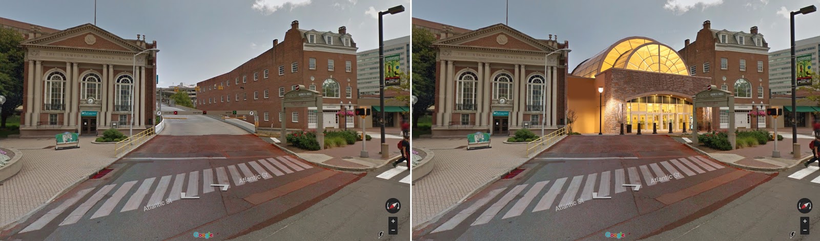
In the previous post, I showed one way the mall could be opened to the street by demolishing one of the car access ramps:

At present, left, and after new entrance.
Additionally, entrances could be punched into the mall at various other points on the exterior, as most parking is actually above the mall, and shopping can be accessed at most points directly from the street.

Narrowing Other Streets

Atlantic Street, onto which this mall entrance faces, should be narrowed from three to two lanes throughout its length with a bike lane added.  A shared space arrangement with bollards (bollards inside the bike lane) would be an ideal treatment.  A new street of 16' or so (not shown) should be run past the facades of these buildings, through the adjacent park, under the mall and into the remnant stub of the old Main Street.  Half of the overly-large park (really a paved square) should be sold off to private parties to construct new buildings along the southern boundary of this new street, leaving a still-large triangular square bounded on all sides by rights-of-way.  

The city should also use its power of eminent domain to open new streets and to complete those discontinuous fragments that already exist.  The below map shows existing streets in red, pedestrian paths in orange, and suggested new streets in yellow:


These new streets also include a pedestrian bridge over Mill River at the upper left, the new 16' street referenced before curving through the park, a new arcaded street through the mall, and two streets creating a three-part division of a large, partly unbuilt block at the right.  Other segments have been added here and there, and the continuation of Summer Street is visible in the center right.

Transportation

Regarding transportation, despite the likely high cost, it may be desirable to create a second stop in downtown Stamford at either Canal or Elm Streets or along East Main Street.  This would help convert the train system into a small localized rapid transit system, and has parallels elsewhere on the line with New Haven's State Street station, Bridgeport's planned second Barnum station and Fairfield's Metro station.  

A full infill station, complete with station house, was built in West Haven for $80 million, though the Bridgeport's station's cost appears to be nearly double that.  Since Stamford is the last stop for many express trains, it would not unduly interfere with express train operation.  An Elm Street or East Main Street station serving the Cove neighborhood and providing a secondary downtown route might be very popular and would not require much parking.  There is ample room for it, and the existing overpasses dating from the turn of the century, will need to be replaced sooner or later.


Optimistically, a plan like this would have a ten-year time-frame from initiation of planning to start of operation.

Parking

Parking is always one of the thorniest issues in downtown planning, but Stamford, for better or worse, is "blessed" with an abundant supply of garage parking.  In particular, the mall parking lot and the Target parking lot are greatly under-used.  In light of this parking supply, if parking minimums cannot be abolished entirely, the city should offer fee in lieu of parking to any residential developer who secures a parking arrangement with one of these local operators.  The number of spaces required to be secured should be as low as politically feasible.

It goes without saying that on-street parking rates should be dramatically increased in the downtown area.  The city is currently attempting to raise additional revenue by imposing new fees on outdoor dining spaces, yet the parking adjacent to it continues to be greatly underpriced.  Although I am generally opposed to on-street parking in areas with high pedestrian volumes, a Shoup-inspired approach that used increased fees for civic improvements could be a positive change.

What Not to Do

Stamford is currently undergoing a major redevelopment project in the Harbor Point area, a former mixed industrial and residential area in the South End of the city, west of the canal.  Although purportedly the handiwork of planners, the haphazard arrangement of streets and commercial spaces creates an environment which at best, is reasonably pleasant, but which at worst is less than the sum of its parts.  

Here are some examples of the decent, the bad and the ugly.  One of the newest areas features a semi-shared space street (interesting) with use of bollards (good), yet the space is overly large (not good) the architecture is completely cold and indifferent (not good) and the scene is altogether too busy with too many plantings (not good).  There are a couple of restaurants along the street to the left with outdoor seating, which greatly helps to enliven the area in the warmer months.


For contrast, here is a street in between two apartments, lined with garages and electric equipment.  This is an unpleasant and even dangerous street to walk down, and it is right off the main park square!


Most unforgivably, in another area close by, is this facade on the local neighborhood commercial main street.  I generally try to steer away from strong language so that readers may make up their own minds, but this is simply atrocious.  The street level must be done better than this.


There are many other changes large and small that one could consider throughout Stamford as a whole, and the city does seem to be engaged in a process of gradually narrowing intersections by bumping out sidewalks, thereby improving pedestrian safety.  With several recent and well-publicized deaths of pedestrians, this needs to be an immediate focus and priority.  Zoning needs to be reformed as well, but that is a post that I have already written.

Monday, December 21, 2015

That 70s Urbanism

1970s suburb, Birmingham, AL.
The 70s, as much as any decade from the 1920s to the 1990s, has gotten a bad rap in contemporary urban planning circles.  It was the golden age of the suburb and the nadir for many urban areas around the United States, not to mention a boom time for highway construction and the development of very low density suburbs on non-gridded street patterns.  Surely there is nothing we can glean from this time period that has applicability to the urbanism of today?

Well, this is perhaps not entirely true.  The 1970s, as well as the decade before it, arguably represented the first time in the urban history of America that planners self-consciously pursued entirely pedestrianized environments, although the inspiration for these areas went back to flights of imagination from the 1920s if not earlier, and the 1950s saw the genesis of several of these ideas, at least in their embryonic forms.    I refer not only to pedestrianized main streets, but to the five great pedestrian creations of the age: the enclosed shopping mall, the international airport, the vacation resort, the convention center, and the network of tunnels and/or skyways.  Each of these represented a vision, if incomplete, for pedestrian-only circulation and commerce on a grand scale, often on the footprint of a small town.  

Do I jest?  No.  The future, if the human imagination is a key to the future, was pointing toward pedestrianism in the 1960s and especially 1970s.  This was, after all, the age of Paulo Soleri's implicitly pedestrian-centric arcology.  Gas prices were soaring by the early 70s.  The 1939 World's Fair vision of high-speed highways was out, and a more refined tecnho-utopianism involving futuristic megastructures was in.  The great majority of the buying public rejected this vision for their private lives, but as the success of enclosed malls shows, they gladly embraced it in many other contexts -- in commerce, for employment, in travel and for recreation.  

The arcology: no highways here, or at least, not the central element! Source.
The tunnel system of Houston and the skyway system of Minneapolis, both begun in earnest in the 1960s, were built out through the 1970s.  Enclosed mall construction, which began in 1956, was in such a boom that four enclosed malls opened from 1969 to 1980 in the city of Toledo, Ohio alone.  Air travel multiplied through the 1960s and airports were expanded on an unprecedented scale.  The very idea of the convention center, although it had been around for decades, attained gargantuan scale by the latter half of the 20th century.  

The hostility toward these type of environments in recent years, has, it seems to me, been based on two primary grounds: 1) the environments, being private and privately controlled, are corporate and sterile; and 2) although the environments themselves may be pedestrian, they are dependent for their business on car-driving customers.  Of these two critiques, however, the second is not inherent to the form of the structures themselves.  Rather, a pedestrian environment such as a tunnel system or an enclosed mall is, as the cities of Japan or Korea bear witness, a better partner to transit and walking trips than it is to car transport.  That the United States largely squandered its opportunities to integrate these structures and systems into its transit networks is an indictment of city planning, but not necessarily of these forms themselves.  

The Japanese, arguably the best city-builders in the world, have not missed this point, and typically have built shopping malls either adjacent to or, in the case below, on top of railway stations:

Osaka's Keihan Mall, over the Kyobashi railway station. Bing Maps.
In the case of American cities, even where the option is obvious and available, no such plans are made.  In Stamford, Connecticut, where nearly the entire downtown was condemned and bulldozed in a vast urban renewal scheme, the new enclosed mall built by the city's hand-picked developer was inexplicably not located next to the city's heavily-used Metro North railway stop:

The mall, at top right, and station, at bottom left.  Bing Maps.
What were they thinking, one could ask.  Note also the very low value placement of the interstate highway just north of the railway line, although this area probably had higher property values than the south side of the tracks at the time of the highway's construction.  In truth, the Stamford planners had given up entirely on any idea of pedestrian circulation outside the new megablocks.  The curated spaces within the new mall were designed to be accessed by car alone, and the structure to this day presents a fortress-like appearance to the outside.  The decision cannot even be explained by a desire to exclude train riders, who then and now tend to be well-heeled commuters to New York and are in general better off than most.

Had the planners of the 1970s left the city alone, and simply redeveloped the train station as a mall, who knows what might have happened by today?  Yet these questions need not be hypotheticals.  Cities have the power to make these changes today.  Stamford cannot move its mall, but it can consider a new infill station closer to it.  It can consider how to improve pedestrian mobility.  It can revamp its bus network.  It can do many things to address past mistakes, but it must be able to understand its mistakes, and even more importantly understand how these creations of the 1960s and 1970s can be a force for good, not merely magnets for a car-driving public.

There are a few easy steps that can be taken at first.  If Stamford wants to fix its mall, tear down one of the car ramp entrances, already duplicated by two others, and install a prominent pedestrian entrance, like so:


Easy?  In the grand scheme of things, yes.  Expensive?  Not terribly.  A bolder step would be an entirely new infill station, one closer to the mall, perhaps at one of the locations highlighted with a green arrow:


Plan a new station.  New Haven already did it, twice, and Bridgeport is doing it, so this need not be some impossible fantasy.  The overpasses need to be replaced anyways, so merge the projects.  Use the gains in real estate value to improve pedestrian connections.  Narrow the streets.  Add bike lanes.  It need not be that difficult!

If hostility toward the idea of enclosed malls, or skyway systems, or convention centers is retained, however, then cities may or may not succeed at revitalization, but they will squander again an opportunity to use these forces for good rather than ill.

---------------

Other reading:

See Mallville by Andrew Price for a related perspective on the traditional city aspects of the American mall.

Saturday, December 19, 2015

The Old(er) Way of City Planning

I've been reading through the 1912 "Plan of the City of Hartford" by the legendary firm Carrère and Hastings, a document which encapsulates some of the best conventional wisdom of that or any era in terms of planning, but which also foreshadows some of the profession's darker moments later in the century.
An ambitious comparison: Saxony's Dresden
as model for Hartford, CT's Capitol area.

There are many noteworthy aspects of the report, most prominently the heavy influence of European
laws and physical plans, and in particular plans of the cities of the German and Austrian Empires, an influence which would permanently fade after 1914.  Many of the cities featured in photographs as models for American cities to be followed were, only three decades later, obliterated in bombing campaigns, resulting in a physical destruction to complement the ideological and academic shifts in focus.

Although the laws of foreign countries provide as much to learn from as ever, as highlighted in Sonia Hirt's latest book, the report is significant to me for its focus on what was once called the street plan, a plan of such antiquity that it preceded zoning plans by millennia, going back to the Romans and further, and which was famously employed by American planners in such cities as New York, Savannah and Washington, D.C.  Rediscovering these plans has been a research focus of planner Paul Knight, who has devoted a website to the subject (I highly recommend his presentation on the subject, along with co-contributors available in PDF here).

The street plan, in antiquity and down nearly to the present day, was considered part and parcel of infrastructure along with sewer needs, fresh water and other necessities.  Not only major arteries, such as the old Roman inter-city roads, were considered as an object of central planning, but minor residential streets as well.  The 1912 plan explains the main rationale for this apparent micro-management as follows:


Reasonable enough?  One can read evidence of the practice of street development in the municipal proceedings of the era in a time before the existence of subdivision regulations, here as it turns out from Hartford's own Common Council Board in August, 1912:

In other words, while the developer would propose a street alignment, this was considered by the city planners in the context of the city plan itself, which at the time would have included a street plan.  Thus, for a developer to obtain approval of his proposed street, it would likely be to his benefit to have it agree with the city's pre-existing plan.  Thomaston Street, which exists today, fits seamlessly into Hartford's irregular, but generally continuous and interconnected, street pattern.  The street would also be a public one, but the plan was in conformity with the city's own plan for growth, and with such extensions happening incrementally, the city was unlikely to be overburdened with long-term maintenance obligations by such a development process.  Note also that Mr. Thomas named the street after himself, or so it seems -- apparently naming rights were vested in the developer, as a sort of added incentive.

Paul Knight's illustration of street-plan led vs. zoning led urban development.
But what of Carrère and Hastings' own plans?  A picture is worth a thousand words in this context, and fortunately the authors left us with some detailed renderings for street grid expansions.  Here the city "general plan," which as can be seen is a street plan, is presented in its entirety:


There is no zoning here, and no historic preservation overlay, although the heights of buildings were automatically limited relative to street width.  Notably are the large ring boulevard, cast as the Ringstrasse or Unter Den Linden of Hartford, but which equally appears to anticipate a grade-separated highway encircling the city.  Overall, the map delineates the public realm of the city: the streets, parks and certain public buildings, those things which were considered appropriate objects for planning.

Note also the newer planned areas to the corners of the map.  In contrast to the irregular grid of existing Hartford, these areas are drawn in a style which is clearly influenced by German neo-medievalist planning fashions of the day, but which again are also anticipating the curvilinear, limited access suburban developments of the late 20th century.  Nonetheless, the areas are drawn in in complete detail, with all, or at least most, subsidiary streets represented.

The planners note that Hartford was undergoing a period of small multifamily development, but are disappointed at the limited options for ownership under current laws.  One wonders whether they had pondered a condominium style of ownership, which at the time was still many years in the future.  In the absence of such laws, the only realistic option was for the freestanding house (common in Hartford) or the rowhouse (very uncommon in the city).

--------

What is sobering to realize from the vantage point of a century later is how utterly the City Beautiful movement, as represented by this crowning document, failed in its efforts to ape the grandeur of the European city, and how thoroughly it succeeded in anticipating the primacy of the car and the rash of road-widenings and "stroad" construction that would follow in its wake.  After 1914, in fact, much of even the desire for inhuman-scale grandeur would fade, to be replaced by cold engineering and mechanical precision.  Dresden was never again to appear as a serious model for Hartford or, most likely, any other American city, and certainly not after 1945.*  And the street plan?  It was eliminated, either folded into "comprehensive plans" or dissolved into subdivision regulations that, using 1930s FHA standards, encouraged the excessively wide streets that the Hartford planners warned of.  In most cities, only the zoning plan survives, with no separate street plan at all.  Streets, many of them private, take selfish, non-connected forms, with the result that greater and greater volumes of traffic are channeled onto fewer and fewer roads which must therefore take on ever-increasing dimensions to handle the load.

In a few fast-growing American and Canadian cities, such as Toronto and Dallas, something of a street-plan led growth pattern is visible, and in most Mexican cities such a process continues today.  But in other cities, there still may be something to take away from these old plans despite their failures.

---------

*Dresden's historic center is currently undergoing a major rebuilding project, indicating that Dresden may be built again, from scratch, before the original City Beautiful plans are fully realized in Hartford.

Saturday, March 21, 2015

Single Family Zoning: It's All About the Lot Sizes

Contemporary critiques of zoning take several forms.  First, and probably most common, is the critique of strict use segregation in the Euclidean manner, with commercial and residential areas segregated to greater or lesser degrees.  An increasing focus has lately been placed on the relative preponderance of single-family detached residential zoning within urbanized areas.  A third line of critique, which has received somewhat less attention although it has been the subject of numerous academic studies over the years, looks at minimum lot size requirements within both single-family and multifamily zones.

Although it may seem like a minor subject next to the first two critiques mentioned, the second critique is incomplete without examining permitted lot sizes.  For instance, even though a city may have substantial areas set aside for multifamily housing, if the minimum lot size per apartment unit (or floor area ratio equivalent) is approximately equivalent to single-family zones, the density and/or affordability difference may be minimal.  Alternatively, the single-family detached ("SFD") zoning designation, by itself, tells us little about the density of the area.  Depending on the lot area required and right-of-way widths, SFD densities for a given household size can range from 300/square mile to as much as 25,000/square mile or more, all without the need for any party walls.  

A few concrete examples can help illustrate the point.  In the American context, despite the presumed consumer preference for SFD homes, neighborhoods of homes on very small lots and using narrow rights-of-way, such as are abundant in many other countries, are quite rare.  In the entire New York metropolitan area, for instance, there are only a handful of such neighborhoods, mostly those intended as beachside retreats along the southern shore of Brooklyn and on the Rockaway Peninsula.  One such neighborhood is shown here:


This is Gerritsen Beach, in Brooklyn, showing parcels of 1,800 square feet on a right-of-way (property line to property line) of 28'.  The 2010 Census gives a population density of over 17,000/square mile, about half of the average for Brooklyn, although this may be affected by the presence of second homes.  As Nathan Lewis has shown, similarly scaled neighborhoods in Tokyo attain densities exceeding 30,000/square mile.  Even so, it is about 80% denser than the densest SFD suburbs built in Nassau County during the 1940s-1970s.  It is more than twice as dense as Levittown itself, and denser even than the three-decker neighborhoods of cities like Worcester, MA or New Haven, CT.  The New York metro area has a conspicuous absence of neighborhoods of this density and type, with Census tracts swiftly falling off from around 25,000/square mile to 10,000/square mile.

Beach neighborhoods seem to be popular settings for this type of design, as a similar (but slightly lower) density is present in Long Beach, California, shown below.  Lots are around 2,400 square feet with a 40' right of way and alleys of 13' (comparable density appears to be achieved through presence of small apartment buildings):  


And here is Levittown itself, with lot sizes of around 6,000 square feet and right-of-way (between outer sidewalk edges) of 50'.  Population density is approximately 7,500/sq. mi.:  


The Levittown homes in their initial form, intended for the large families of the Baby Boom era, were actually somewhat smaller (800 sq. ft.) than the 1920s vacation cottages of Gerritsen Beach (1,000 sq. ft.).  The contrast of very small houses with lots the same size or larger larger than those typical of the pre-1940 period seems to have been characteristic of the time period, perhaps related to the increased cost of labor following the Great Depression combined with stable land values.  The more spacious lots may have offered some compensation for the modest interiors.

At the extreme is the ultra-low density of interior but non-rural New England, showing 2- and 3-acre lot zoning (here, in Easton, Connecticut), accompanied by wetlands regulations, with population density of around 260/square mile:


Now, if a rapidly urbanizing country wished to offer the possibility of ownership of a SFD home to the greatest possible portion of its population, the obvious policy goal would be to allow construction of a SFD home on any size lot desired, and on streets as narrow as possible so as to minimize economic waste.  The result is very much what we see in most of the wards of Tokyo as well as in Gerritsen Beach: very small lots but with practical (square-shaped) dimensions along narrow streets and no alleys.  Where multifamily buildings are not prohibited, these will be interspersed here and there, sometimes occupying two or three lots.

In practice, however, American zoning does not take this approach, with the sole exception of mobile home parks (which I've discussed here).  Not only are lot sizes strictly regulated for SFD zones, generally to standards far in excess of what is needed for a comfortably-sized home, other policy measures are in place that make small lots difficult to build as a matter of economics, such as:
  • Apparent aesthetic preference for large, widely space multifamily over densely packed single-family in multifamily zones.  Although small multifamily buildings have fallen out of zoning fashion, if they were ever popular, those zones that survive have some curious features.  For instance, one Connecticut town's code, typical of the type, effectively grants density bonuses for building duplexes and triplexes over building two or three standalone houses on the same lot.  In the densest zone it is possible to build a single-family home on 5,000 sq. ft. -- the smallest SFD lot permitted in any zone -- but a duplex requires only 7,500 sq. ft. and a triplex only 9,000.  The policy intent here is not obvious, but implies aesthetic favoritism for retaining large dwellings with generous spacing even at the expense of the single-family ideal.  
  • Minimum street widths.  Although these do not affect the lot size directly, mandated wide streets make small lots for SFD a less economical proposition.  For instance, were the Gerritsen Beach lots placed along the Levittown right-of-way, each 1800 sq. ft. lot would look out onto 3,000 sq. ft. of sidewalk and roadway!  The neighborhood, overall, would have a ratio of 1.2:1 of private land to right-of-way, or, in other words, only 55% of the land would be in private lots for sale.  Levittown's ratio is a far better 3:1.  With a 28' right-of-way, Gerritsen Beach's streets are already about as wide as economically possible in light of high land values, and streets of Japanese dimensions would yield a far better ratio.
The design differences produce some noticeable differences even at the very large scale.  The prefecture of Tokyo, with population 13.2 million, has a homeownership rate of 45%.  The city of New York, with population 8.4 million, has homeownership of 32%.  Although the prefecture's density is lower than New York's (16,000 vs. 28,000/sq. mi.), Tokyo's outer suburban areas are so much denser than New York's that its metropolitan area density is higher.  For the entire metro area, Tokyo maintains a 56% homeownership rate with 47% share of detached houses, as compared to New York with 52% homeownership and 36% SFD share.  Los Angeles, to pick another example, has 49% homeownership with 50% SFD stock.

A metro area of more comparable size to New York's, such as Kyoto-Osaka-Kobe, has a homeownership rate of 58%, higher than the entire state of New York, and not much lower than far smaller American cities commonly associated with low-density SFD housing such as the Houston MSA (60%), Dallas (61%), Atlanta (63%) and Phoenix (63%).

Interestingly, the issue of minimum lot sizes appears to be one on which there is general agreement between the Smart Growth faction and the defenders of suburbia, as Wendell Cox wrote some years ago in response to critique from the Brookings Institute:
"I was even more surprised at the claim that I defend 'anti-density zoning and other forms of large lot protectionism.' Not so. 
Indeed, I agree with [Jonathan] Rothwell on the problems with large lot zoning. However, it is a stretch to suggest, as he does, that the prevalence of detached housing results from large lot zoning. This is particularly true in places like Southern California where lots have historically been small and whose overall density is far higher than that of greater New York, Boston, Seattle and double that of the planning mecca of Portland."
I think that Cox is correct here, but not even as correct as he could be.  Large-lot zoning not only does not cause a prevalence of SFD housing, it limits it, as shown in the New York metro area.  Los Angeles' metropolitan density is substantially higher than New York's (a point often raised to incredulous reaction), but its share of SFD stock is much higher.  To point out in response to an allegation that a city is heavily zoned for SFD that a majority of its housing units are in multifamily structures (in the case of Seattle, at the link) only underscores the point.

Although most studies have found that minimum lot sizes do affect overall development density (that is, developers appear to build at or near the minimum lot size allowed), one study of Maryland suburbs of Washington, D.C. found that, except in the case of areas with very large minimum lots sizes, developers were subdividing into lots larger than the mandated minimum, including in cases where planned unit development options left them with a free hand to build denser than the zoning code superficially allowed:
"We then examine the extent to which lot size is being constrained by regulation by comparing actual subdivision density to the allowable density under zoning rules. This analysis is done for three counties with different degrees of suburbanization. We find that only in the areas with the very large lot zoning does zoning seem to be constraining actual lot[] size. There is a good deal of excess capacity in the density that could be built, especially in the more densely zoned areas." Lot Size, Zoning, and Household Preferences:Impediments to Smart Growth?
There might be no concern with low-density development at the fringes of metro areas except that such areas, once built up, are politically almost impervious to change.  Some cities have implemented maximum lot sizes, but these are generally very generous and only apply in certain areas.  The misunderstood achievement of the New Urbanism, and the Maryland suburb of Kentlands in particular -- whatever its faults in design detail -- was that small lot single-family housing developments not only need not be qualitatively inferior to the 6,000+ sq. ft. tracts that characterized the post-1940 suburban era, and that they could even offer amenities that made them superior residential environments.  Where regulatory mandates fail, leading by example can succeed.

Kentlands, with SFD lots from 5,600 to 2,600 sq. ft, and with ROWs ranging
from 45 ft. to 12 ft. on alleys.
Related posts: None of mine, but Nathan has written several great pieces on the topic which you can find at his website.

Saturday, September 7, 2013

New Plans for Old Avenues in New York City

In its recent endorsement in the New York City mayoral race for sudden frontrunner Bill de Blasio, StreetsPAC cited de Blasio's street safety platform calling for "a city with zero fatalities or serious injuries caused by car crashes on the streets of New York." In addition to various law enforcement measures, including speed limit reductions, de Blasio's platform also calls for design-based changes, including "narrowing excessively wide streets that encourage reckless passing and speeding, widening sidewalks and medians to make streets easier and safer to cross, and adding dedicated bicycle infrastructure to create a safe space for New Yorkers on bikes."

Under Mayor Bloomberg, numerous design interventions of this sort have been carried out, and although some redesigns have brought significant transformations -- Times Square, for example, or the reworking of Grand Army Plaza in Brooklyn -- others have been little more than glorified patch jobs, taking common-sense but modest steps to address notoriously dangerous crossings and intersections without unduly interfering with the primacy of high-speed automobile circulation. While there has been abundant use of colorful paint to widen sidewalks and expand pedestrian plazas, and the wonderful addition of bike-sharing and new bike lanes, few streets have seen thorough overhauls that are consciously geared toward improving quality of life for those on foot rather than simply enhancing safety and mobility.

Incremental changes make sense as a general rule, but in a city like New York, surely there is room, and appetite, for at least one transformational street project?  However, certain major changes, such as wide-scale permanent pedestrianizations, have generally fallen out of favor since the 1970s, while the imaginations of some planners and architects can get carried away in impractical, overly-complex or even fantastical directions when presented with a large blank canvas to work on, as in the case of this fanciful example from last year's Greatest Grid exhibit, showing a Manhattan street repurposed for agriculture:

A more realistic plan is the "Yorkville Rambla," developed by John Massengale and Dover, Kohl & Partners, which would essentially pedestrianize the center lanes of Second Avenue. The plan is simple, elegant, and most importantly, draws on established design predecent shown to be successful in similar urban contexts. The design does not contemplate a complete pedestrianization, but on New York's avenues, due to the need for dedicated bus and bike lanes, this is not likely to be feasible:

Source: Massengale & Co. LLC, Dover, Kohl & Partners et al., via Urban Design Week 2011

The plan pays homage to Barcelona's renowned thoroughfare, but there are in fact successful examples from New York itself very similar to the proposed design. Here, for example, is Dag Hammarskjold Plaza, a city park nearby the United Nations complex which was completely reconstructed in the late 1990s. Although it is classified as a park, and is administered by the city's parks department, rather than the transportation department, when viewed in context of the adjacent 47th Street, it is clear that the so-called plaza is actually a classic urban promenade:

The plaza looking west, with 47th Street at right. Source: Old Urbanist
Its design is brilliantly simple in my opinion, incorporating a few basic principles:
  • Pave, pave, pave. The surface of the promenade is largely covered with functional brick and stone pavers, minimizing maintenance while maximizing the area for human use (which includes weekly farmers' markets). There are few if any concessions to "green" or "landscape" urbanism: no berms, no bioswales, no stormwater filtration areas, and half the right of way is not given over to indigenous grasses or drought-resistant shrubs (there is, however, an adjacent garden, to the far left in the photo, although this is not integral to the design).
  • People-oriented seating. Bench seating is simple and faces toward the promenade, not away from it or in random orientations. If "what attracts people most ... is other people," in William Whyte's words, this straightforward design is a great success.
  • Green to the eye, not green on the ground. During summer, the promenade is luxuriantly green to due an abundance of trees (planted regularly and formally, not pseudo-naturalistically). However, these trees take up very little space at ground level, minimally interfering with use of the space. For me, this is the true mark of a successful green area ratio: maximizing visible greenery while minimizing the street-level square footage actually occupied by that greenery. Planted areas can enliven a very large space, but this should be done with care, and with thought given to what sort of use the space is likely to receive.
Another promising and perhaps even more feasible plan would restore Park Avenue approximately to its early 20th century configuration by widening its median, although the plan by SHoP shown here does put a lot of unusable green space on the ground:

Source: New York Observer.

This seemingly High Line-inspired use of plants to restrict the area available for human use (without adding much visual green -- note the ratio of visual tree area to plant area of about 5:1, though the plant area probably occupies 100x the ground area) seems to be characteristic of many contemporary plans, including one by SOM for the elevated roadways around Grand Central. If that is the cost of deriving political will and public support from the High Line's success, though, then it may be an acceptable trade-off after all.

Whatever the plans of the next mayoral administration, whether led by de Blasio or another candidate, one hopes that at least one street redesign such as these makes it onto the agenda. For a relatively modest cost, the benefits not only in safety but in quality of life would be substantial.

Related posts:
  • Recivilization also features the Yorkville Rambla at a post here, and outlines a set of very similar principles (which I didn't see until after writing this -- showing that there may possibly be something to them!).
  • At Strong Towns, Steve Stofka provides a thorough post on street design and the perception of street width, using the addictive new program Streetmix.

Sunday, June 30, 2013

Common Garage Parking in Practice, Part III: On-street Problems

Norwalk, Connecticut was facing parking problems. Although it had recently built a 775-car parking garage to serve its popular South Norwalk (SoNo) district, a formerly derelict collection of 19th century warehouse, commercial and factory buildings now revived as a bar, restaurant and shopping district, complaints continued to pour in from visitors and proprietors that the area lacked sufficient parking.

To a disinterested observer, these complaints might have seemed odd: the modest row of shopfronts along Washington and Wall Streets were surrounded by off-street parking and had ample on-street parking as well, and the blog Livable Norwalk confirmed that the SoNo area in fact did have an ample supply of parking in the vicinity:
 
From Livable Norwalk: public parking in blue, private in orange.

In spite of the purported lack of parking, the new garage (located a five minute walk from the heart of the area) was a target of particular ire from local restaurant owners, who complained that it was too far away for customers. Several attempts have been made to explain the lack of use of the new multi-million dollar garage in spite of persistent griping about insufficient parking, including:
  • A pricing structure that would give Donald Shoup nightmares. Norwalk charges dramatically more for its garage spaces than for on-street spaces, even though the on-street spaces are scarcer and more convenient. Moreover, the city makes on-street parking free during high demand hours (after 6 p.m. for most streets), while only discounting garage parking. In response to this situation, the city recently hiked prices at its garages while leaving metered spaces unchanged.
  • A poor pedestrian experience. One blogger posted videos to show the allegedly poor quality of the short walk from the garage to the center of the restaurant area, despite the fact that the garage incorporates a retail and office liner around most of its perimeter.
  • An excessively long walk. This is the claim of SoNo merchants and visitors alike regarding the five-minute walk from the garage to Washington Street, although for certain attractions (such as the Maritime museum and a few restaurants) the garage does represent the closest parking option. On-street parking is very limited in the immediate vicinity of the garage.
All of these explanations must play some role here, but one that is unmentioned is, I think, perhaps the most important of all: the presence of on-street parking itself.  Consider the nearby Stamford Town Center, a typical enclosed mall which is reached solely by paid garage parking. A typical visitor will need to walk about three to five minutes to reach a randomly-chosen store from the garage, and possibly as many as seven minutes to reach certain parts of the anchor stores. Yet there's rarely if ever been any complaint raised, so far as I'm aware, that parking is too far from the mall's stores, that that there isn't enough of it, or that the walk through the dim garage is too unpleasant.  

Glance again at the map above, showing the commercial thoroughfare of Washington Street running east to west at the center of the frame. Occupying the entire southern half of the southern block, outlined in blue, is the 265-space Haviland Street parking deck. To the north is the 775-car Maritime Garage. Washington Street itself offers only 22 spaces, in comparison to the over 1,000 public garage spaces in close proximity, plus many hundreds more in public and private surface lots. Although these spaces only supply a tiny fraction of the total, by their conspicuousness they play an outsized role, inducing many motorists to circle the block several times in hopes of winning the parking lottery, rather than simply proceeding to one of the garages.

From a performance parking perspective, one could suggest charging for these spaces at the market-clearing rate, but taking a contextual view of Norwalk's parking policies, that may almost be beside the point. The very existence of the parking spaces, regardless of their cost, exacts a psychological toll on would-be garage parkers by making their walk seem long relative to where, in theory, they might have parked. As long as the spaces exist, garage parking will always be seen as a second-best option. At the mall, by contrast, where the option of parking in front of one's desired destination is completely unavailable, shoppers are indifferent to longer walks and seem to endure them without much complaint.

From the perspective of the merchants, often the biggest boosters of underpriced on-street parking, this apparent drawback of on-street parking is in fact seen as its very benefit. Since shoppers are believed to be tempted by abundant free parking in other shopping areas, the retention of very cheap or free and convenient parking may be seen as essential to create the illusion, for motorists, of the same commodity found in suburban shopping centers (this sentiment is captured well in this article).

That this commodity is not available to 95% of peak-hour visitors regardless of how it is priced is irrelevant, given the same factors at play (that is, the theoretical possibility of a cheap, convenient spot is presumed to carry disproportionate weight in the mind of the potential shopper: the goal is luring them in, rather than actually providing them with the commodity sought).

How to reconcile all of these competing views, which have produced a parking policy that is at war with itself, pitting alluring on-street parking against the city's own garage parking, and cheap, scarce spaces against abundant, expensive spaces – a situation hardly unique to Norwalk? Well, there are several potential options apart from adjusting the pricing structure:
  • Convert the parking lane to sidewalk space. Although New Urbanists generally oppose the elimination of on-street parking, this is generally in the context of effective street widenings, in which the lane is turned over to through traffic rather than pedestrian use. Repurposing street parking for non-automobile uses (a favorite intervention of tactical urbanists, those deconstructivists of the autocentric paradigm), on the other hand, ought to be seen as a positive intervention.  Spanish cities frequently incorporate shared-space streets with through-traffic lanes, and with parking prohibited through use of trees and bollards (see at right, from Barcelona).  There is no reason such an approach could not be used on a much wider street, leaving ample room for sidewalk dining.
  • Total pedestrianization. Another option frequently derided on the basis of several conspicuous failures in the 1970s, pedestrian malls have actually enjoyed tremendous success in dozens of American cities (non-American examples are too numerous to mention). Limited vehicular access for deliveries during certain hours would preserve functionality without unduly detracting from quality of life.
  • Unconventional approaches to parking re-use. In a recent post, Matt Yglesias suggested that one way to deal with residents' fears of spillover parking generated by new development might be to eliminate residential parking permits and deed on-street parking spaces over the adjacent homeowners. Given that merchants would more likely than not be strongly opposed to either of the previous suggestions (but not always -- see an example of Minneapolis restaurants supporting a sidewalk expansion into street parking here), the same approach could be used in a commercial context. Establishments would be free to use the on-street space for their own parking, for some other use, or could simply sell the rights to the space to another merchant. 
In a new development, at least, one would hope that these knotty, politically divisive issues could be dealt with in a comprehensive, consistent and economically rational manner, yet at the planned Waypointe mixed-use development north of SoNo, renderings and promotional videos appear to show on-street parking despite the presence of a 1025-space parking garage (incorporated Texas doughnut-style).  Even if no such parking is actually part of the formal plan, the ample width of the carriageways implies, and will likely result, in their eventual presence.


Related posts:
Common Garage Parking, In Practice
Common Garage Parking, In Practice: Part II