Saturday, December 12, 2015

Lot Sizes: Regional Trends and Causes

In a prior post, I examined minimum lot sizes as a general concept with reference to a few examples.  Another way of approaching the subject is to examine regional and national patterns and trends on lot sizes.  Although the subject doesn't get a great deal of attention, and Census information is not as detailed as one might like, it is possible to cobble together some statistics.

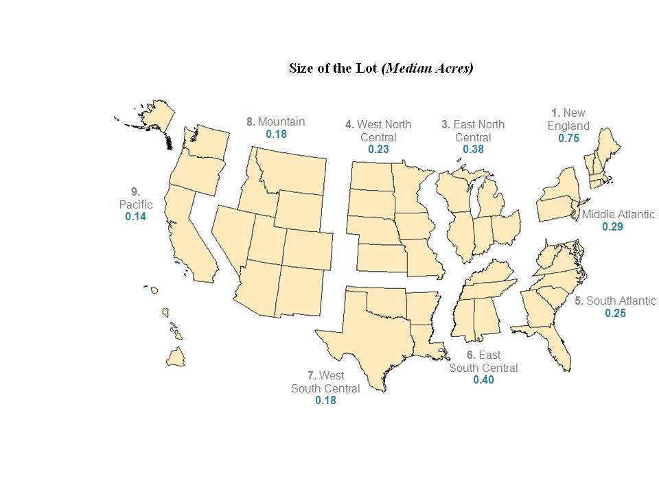
Based on data from the MLS as compiled by Realtor.com, here is a map showing the median lot size of properties offered for sale in each state (for 2012).  As we'd might guess, the patterns reflect both complex historical influences as well as current degree of urbanization:


More relevant to current debates over urban expansion and development are the median lot sizes of new homes, as compiled by the Census.  Unfortunately, the data is not broken out by state, but the regional trends are nonetheless interesting and helpful:

Source
As far as I can tell, rather than primarily being the product of planning and development policies, these differences are substantially driven by agricultural land values as well as groundwater availability.  Federal land ownership may also play a role in some western states.  A map of well-water supply is below, showing a fairly good correlation with lot size:

Source
The outlier value for New England in the median lot size map seems to fit the well-known historical account of agriculture in that region, where after the arrival of railroads carrying midwestern grain in the later 19th century, farms were rendered unprofitable and were abandoned en masse, leaving only stone walls -- 250,000 miles worth -- through new-growth forests as a sign of their former presence.  During the height of this abandonment in the 1890s, some New England counties, like Tolland County in Connecticut or Rutland County in Vermont, actually declined in population.   Post-1950 tract homes in New England, built in forested, rocky terrain, prefer to sit Walden-like in their own little forest clearings, as though each homeowner were an 18th century pioneer carving out a homestead in the wilderness.  Much of New England, as William Fischel also notes in Zoning Rules!, with a wet and cool climate, is heavily well-watered, with the result that homes need not be clustered closely together.

Outer suburbs of Hartford, CT.
Where agriculture yields the highest-value crops on a per-acre basis, such as in the fruit groves and orchards of Florida or California, the smallest lot sizes are found.  A list of the densest urban areas in the United States is surprisingly dominated by small California cities, such as Davis, Woodland and Delano, most of which sit within the fertile farmland of the Central Valley.  In Florida, meanwhile, the rapid development of The Villages retirement community has produced some of the densest single-family subdivisions in the entire country:

The Villages: homes built for former residents of Hartford, CT.
This ingenious map shows the distribution of cropland and pasture by type throughout the US, highlighting the concentration of agriculture in certain areas and its near-absence from wide swaths of the country, including the majority of New England, much of the southeast apart from coastal lowlands and the mountain and desert west:

Map by Bill Rankin.
In most of Europe and Asia, by contrast, pre-industrial towns and cities of necessity grew in immediate proximity to valuable agricultural land:

Farm towns in Heibei province, east of Tangshan, China.
A few exceptionally large cities of the ancient world imported grain by ship, but for the most part cities were dependent on their agricultural hinterlands.  Until the early industrial era, the high value of this land for crops probably did not impose significant constraints on city expansion (as opposed to the limits of sanitation, transportation, the need for a defensible perimeter, etc), but in an age of rapid population growth and urbanization, the cost of land acquisition gained greater significance.

Where land has little value for agriculture, we should not be surprised to see greenfield development taking lower-density forms.

Wednesday, December 9, 2015

Urban Governance: Merger and Fragmentation

Let's consider two hypothetical cities. For convenience, I'll call them "Hartford" and "Nashville."  Both are state capitals.  Both are favorably located on bluffs overlooking large rivers and are surrounded by abundant buildable land.  As of 1960, both cities proper had comparable populations, with Hartford at 162,000 and Nashville at 170,000.  Hartford was in 1960 by far the wealthier of the two, being located in one of the richest states of the union and hosting the headquarters several of the nation's largest insurance companies, yet housing costs were reasonable in relation to Boston and New York.

From the standpoint of a 1960 observer, Hartford appeared to have the brighter prospects for population growth.  Hartford's metropolitan area, represented by the county of which it was the seat, was in fact growing at a more rapid clip than Nashville's Davidson County, with a population increase of 28% during the 1950s compared to 24% for Nashville, even though Tennessee at the time had a higher birth rate than Connecticut and Davidson was absorbing heavy in-migration from much of the central Tennessee region.

Around 1960, however, two developments reshaped the governance of both cities.  In that year, Connecticut's abolition of county government went into effect, leaving only the state government and 166 town governments, one of which was the rump city of Hartford, a jurisdiction of 17 square miles.  Only three years later, Nashville moved in the opposite direction, merging itself with the 504-square mile Davidson County and forming a consolidated city-county government.

Since 1960, Hartford County has grown 23%, while Davidson County has grown 40%.  By 2010, Nashville's urbanized area population exceeded Hartford's.  As of 2014, Davidson County with 668,000 inhabitants held fully 62% of the greater Nashville urbanized area population.  By contrast, the city of Hartford had lost population since 1960, and with only 125,000 residents held only 13% of the greater Hartford urbanized population.  Nashville's downtown area is today booming with apartment construction, while Hartford has seen little multifamily development since the 1960s.

The factors in the success of Nashville relative to Hartford obviously are more complex than the arrangement of city government, and involve developments as varied as the economic rise of health care and higher education and the general increase in prosperity in the American south relative to the nation during the mid and late 20th century.  Nonetheless, the relative fragmentation or centralization-by-annexation/merger of city governments is of major importance in how cities are run, regulated and taxed.  For instance, consider that a home in Hartford today bears a tax burden more than three times that of a home of identical value in Davidson County.

For the 2010 Census, the list below shows the top and bottom 15 rankings for the population of cities proper expressed as a percentage of total urbanized area population (out of the top 50 largest urbanized areas):


The list of metros with the highest percentages of their urban population contained within their cities includes several of the fastest-growing and most economically resilient cities in the United States: of Brookings' list of the top 10 performing cities over the past several years, five are on this list.  Only one metro on Brookings' list, Salt Lake City, appears on the bottom 15.

Simply because a metro appears on the low end of the rankings, however, does not necessarily mean that it is highly fragmented overall.  Washington D.C., for instance, is surrounded by large and relatively powerful county governments, including Fairfax (1.1 million, 407 sq. mi.), Montgomery (1.0 million, 507 sq. mi.), Prince George's (890,000, 598 sq. mi.), as well as the smaller but populous Arlington County and city of Alexandria.  Others, such as Bridgeport, CT, Providence, RI and St. Louis, MO do have a highly fragmented governing structure throughout the metro area, with a large number of small towns each guarding their own local taxing and land use prerogatives.  County governments fractured into townships tend to replicate, in approximate fashion, the metro areas of non-county states such as Connecticut and Rhode Island.  The proportion of people living within the central jurisdiction is suggestive of degree of fragmentation, however.

I can hear the reader say right now: but correlation isn't causation!  While that is certainly true, and while I also bear in mind Jane Jacobs' comment that a region "is an area safely larger than the last one to whose problems we found no solution," those who have studied this issue have found definite advantages to a more centralized form:

  • Zoning.  Although one might imagine that a multiplicity of jurisdictions might compete with each other for residents, thereby raising the net quality of life, what is observed instead is that jurisdictions attempt to compete for wealthy residents by imposing restrictive zoning regulations.  This results in a zoning race to the bottom, as towns enact ever-stricter regulations to keep prices high.  The result is high citywide housing costs relative to income.  More centralized cities tend to have more permissive zoning.
  • Property Taxes.  A highly fragmented metro tends to have high property taxes as well, due to lack of economies of scale.  Central cities often suffer the most, as they have the largest share of public or non-profit land, and must impose nearly ruinous taxes on the remaining devalued private land to cover basic municipal services.  The taxes further drive down property values, resulting in a situation where (as with Hartford, see below), the situation nearly becomes unsustainable.
  • Education.  As I've written about before, overall educational outcomes in county-wide educational systems funded out of general revenues can be as good or better than even the best and most lavishly-funded local school systems.  
  • Transportation.  In general, regional transportation planning would be expected to have a smoother political course in a centralized city.
There are disadvantages too.  Very local governments, for better or worse, can be (or at least are perceived to be) more accountable to the individual citizen.  These governments may have long histories and impart to an urban area much of its character.  Some of the advantages of the centralized form can be overcome through adopting elements of a centralized form, such as pooling of certain services, without relinquishing all local authority.  

Still, where all else fails, consideration of more drastic measures may eventually become necessary.  In its election just a month ago, Hartford elected a new mayor, Luke Bronin, who defeated the incumbent in an earlier primary.  Although the local paper has wished him well, it closed a post-election op-ed with words that may soon need to be uttered more forcefully:
"The steep challenges facing Hartford and Bridgeport [which also elected a new mayor] raise the question of whether these cities, which have heavy costs and little property to tax, can continue to be viable. The canary in the coal mine on that may be New London, where Democrat Michael Passero, a city council leader and former firefighter, was elected to replace Mayor Daryl J. Finizio.

At seven square miles, New London is the second smallest geographical municipality in the state. Like Hartford and Bridgeport, it bears a disproportionate amount of its region's social costs. 
If the new mayors cannot make these cities work, we shall have to rethink them."
Whether Connecticut has the capacity to "rethink" the organization of its centuries-old towns is a reasonable question, as is the question of whether any such reorganization would work to solve central city ills.  That the question is presenting itself at all, however, is indicative of the scale of the problems at hand.

Monday, December 7, 2015

Single Family Zoning in Seattle and The Limited Logic of Euclid

I'd wanted to write a few words about the recent controversy over single-family zoning Seattle, but that debate has been addressed so well and thoroughly by other writers that I'm not going to rehash the details.  Apart from the local politics of that debate, one thing that it has accomplished is to assist in highlighting exactly what single-family zoning means in an American context.

Although it sounds self-explanatory, the term "single-family home" has a distinct perception and legal meaning that goes well beyond the mere physical form of a dwelling.  Through a series of court cases, including the Euclid v. Ambler decision, American courts have gradually allowed the enshrinement of this perception into law with hardly so much as a dissenting opinion.

Many of those debating single-family zoning in Seattle (and in other cities) take these various legal incidents for granted as an integral part of an area devoted to standalone houses, although they are conceptually and legally separable.

The American Conception of the "Single-Family Home"

The typical American single-family home, and the zone within which it lies, are defined by (at least) five key legal elements which I've laid out below.  I call this conception "American" in line with Sonia Hirt's analysis in her recent book, Zoned in the USA, where she discusses how the single-family zone, as defined below, is a century-old American invention, and is rarely found in the land use codes and regulations in other countries.
Although the the debate generally focuses on the third of these (limitations on units), and sometimes the fourth, each of these supporting elements are essential to sustaining the American ideal of the single-family zone.  Remove any of them and the concept breaks down.

That allowing some non-residential uses would transform single-family areas seems too obvious to mention, although the consequences of doing so are often greatly exaggerated.  Many residential streets are simply not economically viable sites for commercial activity, and certainly not those which depend on a high volume of customers.

An abolition of minimum lot sizes, in fact, might be even more transformative.  On the typical housing lot of 6,000 square feet bordering street and alley, three or more detached homes might be built.  On Twitter,  Mike Eliason provided a photo of how this very result was feared by the incumbent homeowners of the 1920s (at right).  These were single-family detached homes, to be sure, but they violated the perception of what a proper single-family home should be (aside from stirring up various other anxieties and prejudices).

Setbacks and FAR limitations predated limitations on units, and in conjunction with minimum lot sizes were used to achieve the same result, as well as to enforce aesthetic preferences (specifically, for large front lawns).  With their intention of making impractical and uneconomical all but detached, one-family houses, they incidentally also forbid other types of single-family housing, including the ancient typologies of courtyard homes and rowhouses.

Limitations on units are the the essence of the single-family designation, and lend the category its name.  This limitation often tests the bounds of rationality and common sense: on what ground, for instance, could one permit single-family homes on lots of 5,000 sq. ft. but prohibit a two-unit structure on 10,000 square feet?  Occupancy limits, covered thoroughly by Alan Durning in a series at the Sightline website, are a means of closing a final loophole and preventing detached, single-unit homes from being adapted to multi-household use as dormitory-style SRO housing with shared kitchen or bathroom spaces.

Zoning Ideology and Housing Prejudice

As should be clear from the above, the single-family zone, far from the straightforward concept that it it pretends to be, is a complex and artificial legal construct with many interlocking parts designed to forbid any deviation, no matter how slight, from the ideal.  Nor is some universal concept which is simply given recognition in law: in many or most countries, the idea of regulating housing in such a manner is not even conceived of. In Japanese zoning law, for instance, only bulk and height are regulated, and no attempt is made to restrict how the space within the building envelope is divided into living quarters.

The phantom triplex: using the language of interior spatial
division to imply differences in outward form.
At the dawn of American zoning, there was some concern that this sort of regulation -- one which specified that having more than one unit in a structure was sufficient to make that structure a different type of use --  would be found to exceed a city's legislative power (this from Edward Murray Bassett's Zoning):


At the time of Bassett's writing, courts had already upheld lot coverage maximums and height limits, which together could be deployed to greatly restrict net buildable square footage on any given lot.  The question remained whether within this building envelope a city could restrict the number of units (kitchens, essentially).  Bassett, a lawyer who always seemed to worry more as to whether courts would uphold his ideas than whether the ideas themselves were sound, was concerned that this would go beyond the legislative purposes for which zoning had been authorized by the states.

By the time the Euclid decision was issued by the Supreme Court in 1926, however, rhetoric was already triumphant over meaning, so much so that it rendered specious nearly all of the court's reasoning with regard to the exclusion of multi-unit structures.  That reasoning, casually tacked on to the court's primary analysis regarding use-based zoning, is set out below:
"With particular reference to apartment houses, it is pointed out that the development of detached house sections is greatly retarded by the coming of apartment houses . . . . Moreover, the coming of one apartment house is followed by others, interfering by their height and bulk with the free circulation of air and monopolizing the rays of the sun which otherwise would fall upon the smaller homes, and bringing, as their necessary accompaniments, the disturbing noises incident to increased traffic and business, and the occupation, by means of moving and parked automobiles, of larger portions of the streets . . . ." (Emphasis added).
All the court is doing here is recapitulating its decision in Welch v. Swasey in which it upheld restrictions on height and bulk (essentially, the establishment of a three-dimensional building envelope).  It does not squarely address whether a city could restrict the number of units in buildings constructed within existing height and bulk limits.*  It does not address whether a city could ban multi-unit buildings even where they are no denser, in units/acre, than single-unit structures.  It does not address whether parking concerns are valid in an area where on-street parking is prohibited or where parking and traffic is managed by some other means than the one imagined by the court.  In other words, Bassett's primary concern regarding the constitutionality of single-unit structures, as a separate use, goes entirely unaddressed. 

Without a concrete controversy before it, the court had no need to utter the notorious words in the passage above, which as noted above were largely irrelevant to the actual issues in controversy surrounding multi-unit buildings.  It would have sufficed to note, as the court actually did later in the opinion, that zoning ordinances must be assessed in detail rather than in generality.  The court realizes this toward the very end of the opinion: "In the realm of constitutional law especially, this Court has perceived the embarrassment which is likely to result from an attempt to formulate rules or decide questions beyond the necessities of the immediate issue."  This humble admission appears in the same opinion in which the highest court in the land slanders apartment buildings as "mere parasites."

The court did issue one opinion two years later striking down a zoning law in detail, in the slightly less well-known Nectow v. Cambridge case, but afterwards fell largely silent on zoning.  Bassett's question was not and has not ever been addressed by the Supreme Court, a fact which has been appreciated by a few authors going back at least as far as attorney Richard Babcock's 1983 article The Egregious Invalidity of the Exclusive Single-Family Zone. 

New Jersey's Reaction and the Final Triumph of Single-Family Zoning

A little-known postscript to Euclid, as described in William Fischel's recent Zoning Rules! book, is that the pro-property rights New Jersey Supreme Court refused to be swayed by the decision, instead adopting the narrow reading of it that I have suggested above.  Prior to the issuance of Euclid, the lower court, following New Jersey precedent, had done the following in a process reminiscent of the Mount Laurel doctrine's "builder's remedy" from many decades later:
"The Oxford Construction Company [applied] for a permit granting permission to erect four brick apartment houses upon a plot of ground located at the corner of Highland and Lincoln avenues, in that city. The application was refused upon the sole ground that the zoning ordinance of the municipality prohibited the erection of such buildings in that locality, no suggestion being made that their presence there would constitute a menace to the health, safety or welfare of the public. Thereupon, the construction company moved before the Supreme Court for the allowance of a writ of mandamus to compel the inspector to issue the permit applied for. Upon the final hearing of the cause, it appearing to the court that the presence of the proposed apartment houses in that locality would not endanger the public welfare, health or safety, a peremptory writ was directed."
The city appealed the decision claiming that this reasoning was invalidated by Euclid, but the New Jersey Court of Errors and Appears disagreed and upheld the lower court's result.  In response to this decision, Fischel explains that the New Jersey constitution itself was amended to permit single-family residential as a zoning category.  The text of that initial amendment, which seems to no longer appear in the constitution, is difficult to locate, but in any event the question at issue was not and has never been passed upon by the US Supreme Court.  With New Jersey's pro-property rights judiciary having been outflanked by the people themselves, single-family zoning seemed triumphant.

The Ongoing Debate

Ninety years after the Euclid decision, land use debates in the United States continue to be distorted by this same dichotomy between "single-family zoning" and "multifamily" areas.  Rather than talking about housing in terms of units/acre, or total floor area, or some other similar metric, we tend to use purported building types -- whether single-family, duplex, triplex, ADU or other such classification.  Yet these classifications are in a sense illusory.  Whether a builder puts up three detached homes on a lot, three stacked units in a triplex, or three side-by-side units in rowhouse form really shouldn't matter a great deal to the regulator.

The court's confusion on this point may have stemmed in part from the lack of a concrete controversy.  The respondent, Ambler Realty, was seeking to use its property for industrial purposes, and had no intention of constructing any residential buildings, much less apartments.  The dispute was an abstract one which only pertained to the value of the land.  Had the court been confronted with a scenario in which an individual builder sought to construct a two-unit building conforming to height and bulk regulations within a single-family zone, it could not have evaded the question so easily.

Writing in 1983, Babcock assessed the situation as follows: "Today, there can be no justification under the police power for compelling the construction of single-family houses.  The daring trial lawyer who chooses to litigate this issue will undoubtedly lose in the trial and intermediate courts.  But he should prepare his record with the Supreme Court in view.  Using as witnesses builders, demographers, engineers, planners, environmentalists, and land economists, he should build a record that once and for all demolishes the notion that the single-family detached house is to be forever isolated and protected."

Has this question been posed to any American court in the recent past?  Perhaps not as directly as this, but there have been small victories here and there against unreasonable minimum lot sizes and minimum home sizes in the courts of various states.  Victories have also been won, on occasion, under a fair housing rationale.  A combination of the reasoning from these victories, in the proper context, might yet succeed in the courts of one state or other.

--------------------

*As Alex Cecchini astutely notes in a recent post at Streets.mn, if we assume that the preservation of natural light is a valid purpose under the police power, it is not clear why these concerns are better addressed in a scheme where single-unit structures and multi-unit structures are segregated then where, by contrast, multi-unit buildings are scattered among single-unit structures.  In the former scenario, the multi-unit structures receive abundant light while shadowing only a small number of houses, whereas in the latter the multi-unit buildings all cast each other in shadow, resulting in a net loss in well-lit units.
   

Sunday, June 28, 2015

Fall and Rise of the "Euro Block"

In a recent post, Urban Kchoze's Simon Vallee discusses the traditional "Euro block," that characteristic urban form of European cities from the late 18th to the mid-20th century.  He makes the observation that although the earliest urban development in North American cities adhered somewhat closely to the European pattern, it gradually diverged over time, such that by the wave of industrial-era urbanization in the mid- and late-19th century, the form that apartment blocks took (where they were built at all) was quite different.

Since he focuses mainly on the process that produced these buildings, I wanted to instead examine the form of these various European and American block styles, looking at the particulars of design, density and scale, partly out of curiosity, and partly to see if it is possible to discern any design trends over time.  A good starting point for comparison is a typical Euro block, in this case a Berlin apartment block from the Gründerzeit era, showing the characteristic form that prevailed throughout many of the larger cities of Europe from the late 1700s to the mid 20th century.

I can't pretend to know the exact process that went into the construction of these mietskaserne, but in general, the focus seems to have been on providing for spacious but enclosed courtyards as part of an integrated, block-wide plan.  Although minimum courtyard sizes were established by German building laws in the late 1850s, these were regularly exceeded by the housing associations or cooperatives that built the structures.  Apartment buildings take interlocking forms, with each leaving a blank party wall for future neighbors to build against.  The apartments have good access to natural light, and there are no narrow airshafts.  They were unsanitary and massively overcrowded in the late 19th century, just as the tenements of Manhattan were, but seem to have avoided some of the worst design failings of the New York apartments.  Moreover, the density and integrated nature of the design, combined with the lack of residential-only zoning, was such that each block was capable of establishing small businesses to serve its own residential population.  The specifics are set out below.


Berlin Block
Block Area: 2.23 acres        Block Length: 482 ft.
Stories: 5.5                             Building Depth: 45 ft          
Block Coverage: 78%         F.A.R.: 4.3                              

For contrast, let's examine a typical block of the same era from New York City, in this case from the Bushwick neighborhood of Brooklyn:


Bushwick Block
Block Area: 2.07 acres        Block Length: 468 ft.
Stories: 3                                Building Depth: 70 ft.         
Block Coverage: 81%         F.A.R.: 2.4                             

Although the Bushwick block is much lower density than the Berlin block due to a lesser number of stories, it actually has greater lot coverage and significantly inferior natural illumination.  As the building depth is so much greater than in the case of the Berlin block, the architect has punched airshafts (approx. 8'x13') at intervals down the middle of the row in order to avoid a large number of completely windowless rooms.  Although these airshafts collectively take up over 3,000 sq. ft., that space is inaccessible and unusable.  The long, narrow interior courtyard is sectioned off into small fenced parcels that appear to have little recreational value.

Overall, despite the lower density, the Bushwick block must feel denser and more cramped than the Berlin block due to lack of natural light and paucity of common space.  It is a design that cannot be scaled upwards, either, as much above three stories the airshafts will become useless for the lower floors.  This block design, despite its obvious flaws, was replicated many hundreds of times over Brooklyn and Queens.  Other common approaches included narrowing building depth, which further reduced F.A.R., or breaking up the block into duplexes and their variants, which again left a large amount of airshaft-like unusable space in between buildings.

New York's city planners were well aware of these issues in the late 19th century, as I've written about before, and attempted to address them through the "New Law" building mandates of 1901.  Included among these regulations were minimum dimensional requirements for light shafts of 24', a dimension larger than that set by German building codes, yet still much smaller than the typical Berlin courtyard of 80'x38'.  These dimensions appear to have been designed for purposes of admitting light, rather than for creating usable spaces.


Washington Heights Block
Block Area: 2.06 acres        Block Length: 458 ft.
Stories: 5-6                            Building Depth: 75 ft.         
Block Coverage: 72%         F.A.R.: 4.1                             

The result of these regulations is in some ways even worse than the Bushwick block.  The central courtyard space has shrunk to a narrow corridor which, while it might make a reasonably pleasant narrow street, is here relegated to being a concrete-surfaced no man's land.  Interior open space constituting 28% of the block area, more than in the Berlin block, has been entirely squandered.  This block represents the culmination of a half century of regulations purportedly intended to improve the arrangement of residential quarters, and yet the quality of mid-rise apartment design could hardly fall any lower.  Richard Plunz, in A History of Housing in New York, summarizes the efforts of New York architects and builders, as compared to those of Europe:
"In Europe by the turn of the century, the development of new prototypes for reduced [lot] coverage had reached a level of sophistication unknown in New York until the 1920s . . .  In all cases, the European efforts far surpassed the scale and quality of anything that could be found in New York."  History of Housing in New York, p. 138.
Plunz' assertion is a bold one, and could be quibbled with in the details, but one which seems essentially accurate.  Compared to even the mietskaserne, the sullen apartment blocks of Washington Heights and the Bronx inspired little affection and did not retain middle-class residents or entice new ones.  Following the failure of the New Law regulations to create blocks that rivaled the quality of even the average Euro block, New York planners and indeed the entire planning profession gradually abandoned the concept of the enclosed block, instead adopting either the garden apartment or the tower-in-the-park concept (the first such plan being drawn up in 1917, according to Plunz). Although both of these featured large quantities of landscaped space, very little of it was private and enclosed.

In most American cities, apartment blocks of either the European or New York types were rare, and apartment buildings outside central city areas tended to adopt garden apartment forms.  The dense industrial cities of the northeast, for instance,  accommodated virtually all of their population growth in the 1860-1920 period in cottages and three-deckers, or in slightly larger, but standalone, apartment buildings.  Oddly enough, the Euro block form was very well known and used in these cities at the time, but only for manufacturing plants, as shown in these old illustrations:

The Winchester Arms factory in New Haven, CT, top, and
factories on the east side of Bridgeport, CT, via BIG Map Blog
The suitability of this form for residential use was belatedly discovered some one hundred years later.  The Winchester Repeating Arms Factory, shown in an 1879 illustration above, is undergoing conversion to an apartment block that would not look out of place in contemporary Berlin.  Bridgeport itself did eventually discover the cooperative ownership form for apartment complexes using a somewhat similar design, but not until almost a century later.

Revival of the concept is not limited to loft conversions of former industrial facilities, as the form has lately begun to proliferate throughout the Sunbelt cities.  Simon notices this in his post, too, but I think the form-based similarities are worth exploring.  Below is an apartment "complex" in Dallas, Texas, that is representative of a type found throughout Sunbelt cities.  Even a glance at the overall layout immediately tells us that the form here is much closer to the 19th century Berlin block than to any of the New York examples shown previously: the building uses interior wings to define enclosed but spacious courtyards which serve recreational purposes.


Dallas Block
Block Area: 2.42 acres        Block Length: 330 ft.
Stories: 3                                Building Depth: 75 ft.         
Block Coverage: 81%         F.A.R.: 2.4                            

Very often, decked parking garages are incorporated within these buildings in the familiar "Texas doughnut" configuration, but using a ground level parking area, with courtyard placed over it, seems to also be popular.  Were the buildings made taller and somewhat narrower, as in Berlin, an even better result could be obtained, but this might not be as economical in light of modern construction mandates for fireproof construction above a certain number of stories.

Are there any editorial comments to make in closing?  The American experience with apartment-building seems to have been characterized by planning interventions that were about mitigating perceived shortcomings or excesses rather than pursuing any clear idea of good design.  The Euro block form, in the absence of large developers or cooperatives with access to capital and who are able to design entire blocks from scratch, relies on top-down and forward-looking coordination of a sort which was generally absent in 19th century American cities.  Its complete absence from the wealthy industrial cities of the northeast and midwest is conspicuous.  In spite of that, the Euro block, with its restrained density, generous interior spaces and focus on harmony and aesthetic unity, is a form of urbanism well-suited to American sensibilities.  Its rediscovery in the late 20th and early 20th shouldn't come as a great surprise.

Related links:


Saturday, March 21, 2015

Single Family Zoning: It's All About the Lot Sizes

Contemporary critiques of zoning take several forms.  First, and probably most common, is the critique of strict use segregation in the Euclidean manner, with commercial and residential areas segregated to greater or lesser degrees.  An increasing focus has lately been placed on the relative preponderance of single-family detached residential zoning within urbanized areas.  A third line of critique, which has received somewhat less attention although it has been the subject of numerous academic studies over the years, looks at minimum lot size requirements within both single-family and multifamily zones.

Although it may seem like a minor subject next to the first two critiques mentioned, the second critique is incomplete without examining permitted lot sizes.  For instance, even though a city may have substantial areas set aside for multifamily housing, if the minimum lot size per apartment unit (or floor area ratio equivalent) is approximately equivalent to single-family zones, the density and/or affordability difference may be minimal.  Alternatively, the single-family detached ("SFD") zoning designation, by itself, tells us little about the density of the area.  Depending on the lot area required and right-of-way widths, SFD densities for a given household size can range from 300/square mile to as much as 25,000/square mile or more, all without the need for any party walls.  

A few concrete examples can help illustrate the point.  In the American context, despite the presumed consumer preference for SFD homes, neighborhoods of homes on very small lots and using narrow rights-of-way, such as are abundant in many other countries, are quite rare.  In the entire New York metropolitan area, for instance, there are only a handful of such neighborhoods, mostly those intended as beachside retreats along the southern shore of Brooklyn and on the Rockaway Peninsula.  One such neighborhood is shown here:


This is Gerritsen Beach, in Brooklyn, showing parcels of 1,800 square feet on a right-of-way (property line to property line) of 28'.  The 2010 Census gives a population density of over 17,000/square mile, about half of the average for Brooklyn, although this may be affected by the presence of second homes.  As Nathan Lewis has shown, similarly scaled neighborhoods in Tokyo attain densities exceeding 30,000/square mile.  Even so, it is about 80% denser than the densest SFD suburbs built in Nassau County during the 1940s-1970s.  It is more than twice as dense as Levittown itself, and denser even than the three-decker neighborhoods of cities like Worcester, MA or New Haven, CT.  The New York metro area has a conspicuous absence of neighborhoods of this density and type, with Census tracts swiftly falling off from around 25,000/square mile to 10,000/square mile.

Beach neighborhoods seem to be popular settings for this type of design, as a similar (but slightly lower) density is present in Long Beach, California, shown below.  Lots are around 2,400 square feet with a 40' right of way and alleys of 13' (comparable density appears to be achieved through presence of small apartment buildings):  


And here is Levittown itself, with lot sizes of around 6,000 square feet and right-of-way (between outer sidewalk edges) of 50'.  Population density is approximately 7,500/sq. mi.:  


The Levittown homes in their initial form, intended for the large families of the Baby Boom era, were actually somewhat smaller (800 sq. ft.) than the 1920s vacation cottages of Gerritsen Beach (1,000 sq. ft.).  The contrast of very small houses with lots the same size or larger larger than those typical of the pre-1940 period seems to have been characteristic of the time period, perhaps related to the increased cost of labor following the Great Depression combined with stable land values.  The more spacious lots may have offered some compensation for the modest interiors.

At the extreme is the ultra-low density of interior but non-rural New England, showing 2- and 3-acre lot zoning (here, in Easton, Connecticut), accompanied by wetlands regulations, with population density of around 260/square mile:


Now, if a rapidly urbanizing country wished to offer the possibility of ownership of a SFD home to the greatest possible portion of its population, the obvious policy goal would be to allow construction of a SFD home on any size lot desired, and on streets as narrow as possible so as to minimize economic waste.  The result is very much what we see in most of the wards of Tokyo as well as in Gerritsen Beach: very small lots but with practical (square-shaped) dimensions along narrow streets and no alleys.  Where multifamily buildings are not prohibited, these will be interspersed here and there, sometimes occupying two or three lots.

In practice, however, American zoning does not take this approach, with the sole exception of mobile home parks (which I've discussed here).  Not only are lot sizes strictly regulated for SFD zones, generally to standards far in excess of what is needed for a comfortably-sized home, other policy measures are in place that make small lots difficult to build as a matter of economics, such as:
  • Apparent aesthetic preference for large, widely space multifamily over densely packed single-family in multifamily zones.  Although small multifamily buildings have fallen out of zoning fashion, if they were ever popular, those zones that survive have some curious features.  For instance, one Connecticut town's code, typical of the type, effectively grants density bonuses for building duplexes and triplexes over building two or three standalone houses on the same lot.  In the densest zone it is possible to build a single-family home on 5,000 sq. ft. -- the smallest SFD lot permitted in any zone -- but a duplex requires only 7,500 sq. ft. and a triplex only 9,000.  The policy intent here is not obvious, but implies aesthetic favoritism for retaining large dwellings with generous spacing even at the expense of the single-family ideal.  
  • Minimum street widths.  Although these do not affect the lot size directly, mandated wide streets make small lots for SFD a less economical proposition.  For instance, were the Gerritsen Beach lots placed along the Levittown right-of-way, each 1800 sq. ft. lot would look out onto 3,000 sq. ft. of sidewalk and roadway!  The neighborhood, overall, would have a ratio of 1.2:1 of private land to right-of-way, or, in other words, only 55% of the land would be in private lots for sale.  Levittown's ratio is a far better 3:1.  With a 28' right-of-way, Gerritsen Beach's streets are already about as wide as economically possible in light of high land values, and streets of Japanese dimensions would yield a far better ratio.
The design differences produce some noticeable differences even at the very large scale.  The prefecture of Tokyo, with population 13.2 million, has a homeownership rate of 45%.  The city of New York, with population 8.4 million, has homeownership of 32%.  Although the prefecture's density is lower than New York's (16,000 vs. 28,000/sq. mi.), Tokyo's outer suburban areas are so much denser than New York's that its metropolitan area density is higher.  For the entire metro area, Tokyo maintains a 56% homeownership rate with 47% share of detached houses, as compared to New York with 52% homeownership and 36% SFD share.  Los Angeles, to pick another example, has 49% homeownership with 50% SFD stock.

A metro area of more comparable size to New York's, such as Kyoto-Osaka-Kobe, has a homeownership rate of 58%, higher than the entire state of New York, and not much lower than far smaller American cities commonly associated with low-density SFD housing such as the Houston MSA (60%), Dallas (61%), Atlanta (63%) and Phoenix (63%).

Interestingly, the issue of minimum lot sizes appears to be one on which there is general agreement between the Smart Growth faction and the defenders of suburbia, as Wendell Cox wrote some years ago in response to critique from the Brookings Institute:
"I was even more surprised at the claim that I defend 'anti-density zoning and other forms of large lot protectionism.' Not so. 
Indeed, I agree with [Jonathan] Rothwell on the problems with large lot zoning. However, it is a stretch to suggest, as he does, that the prevalence of detached housing results from large lot zoning. This is particularly true in places like Southern California where lots have historically been small and whose overall density is far higher than that of greater New York, Boston, Seattle and double that of the planning mecca of Portland."
I think that Cox is correct here, but not even as correct as he could be.  Large-lot zoning not only does not cause a prevalence of SFD housing, it limits it, as shown in the New York metro area.  Los Angeles' metropolitan density is substantially higher than New York's (a point often raised to incredulous reaction), but its share of SFD stock is much higher.  To point out in response to an allegation that a city is heavily zoned for SFD that a majority of its housing units are in multifamily structures (in the case of Seattle, at the link) only underscores the point.

Although most studies have found that minimum lot sizes do affect overall development density (that is, developers appear to build at or near the minimum lot size allowed), one study of Maryland suburbs of Washington, D.C. found that, except in the case of areas with very large minimum lots sizes, developers were subdividing into lots larger than the mandated minimum, including in cases where planned unit development options left them with a free hand to build denser than the zoning code superficially allowed:
"We then examine the extent to which lot size is being constrained by regulation by comparing actual subdivision density to the allowable density under zoning rules. This analysis is done for three counties with different degrees of suburbanization. We find that only in the areas with the very large lot zoning does zoning seem to be constraining actual lot[] size. There is a good deal of excess capacity in the density that could be built, especially in the more densely zoned areas." Lot Size, Zoning, and Household Preferences:Impediments to Smart Growth?
There might be no concern with low-density development at the fringes of metro areas except that such areas, once built up, are politically almost impervious to change.  Some cities have implemented maximum lot sizes, but these are generally very generous and only apply in certain areas.  The misunderstood achievement of the New Urbanism, and the Maryland suburb of Kentlands in particular -- whatever its faults in design detail -- was that small lot single-family housing developments not only need not be qualitatively inferior to the 6,000+ sq. ft. tracts that characterized the post-1940 suburban era, and that they could even offer amenities that made them superior residential environments.  Where regulatory mandates fail, leading by example can succeed.

Kentlands, with SFD lots from 5,600 to 2,600 sq. ft, and with ROWs ranging
from 45 ft. to 12 ft. on alleys.
Related posts: None of mine, but Nathan has written several great pieces on the topic which you can find at his website.

Sunday, March 8, 2015

Auto Costs and Housing Costs, or, One Reason the Suburbs are So Appealing

Simon Vallee has a post from some time back about filtering vs. gentrification in which he analogizes the process of gentrification, in North America, to the car market in Cuba, noting that restrictions on supply will tend to boost prices and limit availability of a desired good.  Although the comparison is intended to be illustrative, I think it also highlights a substantive difference which, in effect, subsidizes automobiles at the expense of housing.  First, though, some background.

Going back for a moment to the subject matter of a Nathan Lewis post, we can note that, land costs aside, the sticker price of manufactured housing as compared to a new vehicle is not as different as one might think.  A two-bedroom manufactured home, for instance, of about the size of the average new home of the 1950s, costs only around $41,500 as compared to the price of a popular new sedan (I chose the Altima, one of the best-selling cars in the United States) at around $27,000:


However, when car costs are compared to overall home values, including site-built as well as manufactured homes, a different story emerges.  In 1940, the median home was valued at only 2.3 times the retail price of the average new car.  By 2010, in spite of the crash in home prices, this ratio had risen to 6.4.  Car operating costs have also generally fallen as fuel efficiency and vehicle reliability have improved.  Median rents, not shown here, have grown at an even faster rate than home values.

In short, over the last seven or so decades, car ownership (or leasing) has become dramatically less expensive relative to home ownership or tenancy.  Partly this must be due to labor-saving technologies that have affected car production more than homebuilding: even manufactured homes still require extensive human labor, which has become much costlier (though more productive) since 1940, whereas the formerly labor-intensive car assembly process has been heavily automated and accelerated.  The process of robotically assembling houses, or even apartment buildings, remains in its infancy.

Are long-term, over-inflation increases in home values also linked to increases in land values caused by general urban population increase and restrictive zoning?  It goes without saying that rural land values are lower than urban land values, and the Census homeownership figures show that housing values are lower, and homeownership higher, in more rural states in spite of lower incomes.  Relatively poor and rural West Virginia has the nation's highest homeownership rate, while 100% urbanized Washington D.C. has had its lowest in every Census since 1930.  As Luis Bettencourt writes:
"There are several important consequences for general land use in cities. First, the price of land rises faster with population size than average incomes. This is the result of per capita increases in both density and economic productivity, so that money spent per unit area and unit time, i.e. land rents, increases on average by 50% with every doubling of city population size! It is this rise in the price of land that mediates, indirectly, many of the spontaneous solutions that reduce per capita energy use and Carbon emissions in larger cities. Cars become expensive to park, and taller buildings become necessary to keep the price of floor space in pace with incomes, thus leading to smaller surface area to volume."   The Kind of Problem a City Is.
Urbanization in the era of the automobile in turn causes frictions which lead to pressure for zoning.  American municipal zoning, in its initial formulation and as is still practiced today, is fundamentally a device to politically manage these frictions by restricting the intensity of residential land use.  Though not its stated purpose, it has the effect of increasing land scarcity that is already inherent in the urbanization process, and thereby provides a positive feedback mechanism that puts additional pressure on housing values.

What does this all have to do with cars?  As noted above, the cost of a manufactured home, in isolation, is only slightly more than that of a typical sedan.  As urbanization increases, however, the increasing value of land makes cars, which do not have their land storage cost bundled into the sticker price (unlike Japan does, effectively), seem like a relative bargain.  Some time ago, Cap'n Transit wrote a fascinating series on how New York came to tolerate and eventually permit free overnight on-street parking in the late 1940s and early 1950s.  We would find it ludicrous if someone were to purchase a manufactured home and to drive it into Manhattan on a flatbed expecting the city to provide free land on which to site it, but that was how the story went with cars:
"This [middle-class] conception of the benefits of car ownership has always had a huge bait-and-switch component to it. In New York City in the 1940s it was no exception. When people looked at the price of a car, they didn't figure in $20-35 per month in garage rental. When they got their cars, many couldn't afford to pay and took their chances on the street. Garage owners now had to compete with free street parking and lowered their rates accordingly, which meant that they didn't have enough income to expand their facilities, and resorted to bribing the police. 
"These social-climbing drivers felt cheated, but they didn't take their anger out on the car dealers. No, they felt that the city owed them the free parking necessary to make their cars as affordable as they thought." The right to free parking in 1940s New York
There are therefore two clashing trends: as cities grow in size, the cost of a buying a car declines relative to increases in income and housing cost, yet the actual cost of storing a vehicle is, or should be, increasing rapidly, since cars, like houses, occupy a significant amount of valuable space.  Rather than taking the common-sense Japanese approach of the shako shomeisho (proof of parking), however, American states and cities have engaged in onerous mandatory inclusionary zoning for cars (parking minimums), zoning exemptions (e.g. not counting garages toward FAR limits and allowing parking, but not housing, in mandated setbacks), tax exemptions (only 16 states maintain a personal property tax that covers automobiles) and fringe benefits (the commuter parking benefit), in addition to rent-free public housing for cars (overnight on-street parking).  Whereas in 1940, buying and operating a car to escape urban housing costs simply shifted the balance of expenses, with a car costing almost half as much as the median home, in 2010 the prospect of doing so was much more economically feasible.  No doubt many of those New Yorkers of the 1940s and 1950s eventually drove those cars out of their subsidized parking spaces and off to the far reaches of Nassau, Bergen and Westchester Counties, and who could blame them?

Perhaps the biggest effect of all though, going back to the beginning of the post, relates to the obvious but important point that while housing production, and particularly in-city housing production, is subject to political constraints, car production is not (well, mostly not).  There even seems to be a difference in Americans' moral characterization of those who build homes and cars for profit: while a search for the phrase "greedy developers" returns over 60,000 hits, "greedy automakers" returns only 1,000.  From that perspective, the so-called "drive 'til you qualify" phenomenon, much questioned and criticized, is an entirely reasonable response to this economic reality, particularly given widespread lack of highway tolls. 

Making a full accounting of the political choices that have been made with regard to both housing and transportation is a daunting task, but it does help illuminate the residential patterns we see without the need to resort to moral judgments about those choices.

Related posts: Was the Rise of Car Ownership Responsible for the Midcentury Homeownership Boom in the US?

Saturday, January 24, 2015

Sonia Hirt on the Origins of American Zoning

I've written about Professor Sonia Hirt's work previously, so I was glad to find out several months ago that she had a forthcoming book, Zoned in the USA: The Origins and Implications of American Land-Use Regulation, which would address in detail some of her (and my) major research interests.  Hirt, who received her architectural training in Sofia, Bulgaria before earning a PhD in planning at the University of Michigan, has set out to answer the question which has plagued her since shortly after her arrival in the United States in the early 1990s, when she first encountered an American zoning code:

"How could Americans, whose reputation for being independent and freedom-loving and respecting private property was worldwide put up with such tedious laws governing the building of their everyday environments and way of life?"

The question has been examined before, though perhaps not as directly, and Hirt's citations include many prior books and studies that I have also discussed on the blog, including Robert Fishman's Bourgeois Utopias, Jonathan Levine's Zoned Out, Robert Fogelson's Bourgeois Nightmares, Kenneth Jackson's Crabgrass Frontier, Robert Fischel's papers on zoning and many others.  Even Spiro Kostof and Besim Hakim (who has a new tome of his own focusing on Mediterranean urbanism) receive prominent mentions as Hirt surveys some 4,000 years of land-use regulation reaching back to Hammurabi.  Apart from addressing the question above, another of Hirt's major contributions with the book is to provide a broad-scope land-use comparison between American land-use laws and the laws of several other developed countries, including France, Germany, Great Britain, Russia, Sweden, Japan and Canada.

One of Hirt's conclusions, that the United States is the only developed country of those surveyed, apart from Canada, to widely employ single-family detached residential zones that bar all commercial and multifamily uses, was anticipated by her previous work.  An equally important finding, in my opinion, is that the United States is the only country of those surveyed that does not conduct land use at the national or state level.  Although the federal government and certain states have dabbled in land-use law with housing anti-discrimination policies and anti-snob zoning statutes, and a few (such as Oregon) have delved more deeply into regional planning, there is no national land-use law (despite the federal government owning 650 million acres of land) nor does any state prescribe zoning categories that municipalities must follow.  Hirt also surveys a wide range of US zoning ordinances and finds little evidence that, despite the zoning reforms of the past 20 years, including the emergence of form-based codes, there has been any revolution in American zoning practice either in substance or procedure.

How this exceptionally American land-use system came into being during the late 1800s and through to the 1930s is the primary focus of Hirt's book.  In chronicling this period, many apparent paradoxes present themselves: for instance, although the United States of the late 19th century prided itself on being the most democratic nation in the world, its citizens had a low level of trust in their elected municipal officials.  The progressive municipal reformers of the time might therefore have campaigned for planning to be guided by state or federal governments, but instead pushed for non-discretionary municipal-level zoning.  As Hirt observes, zoning reformers such as Lawrence Veiller argued that "zoning rules should vary as little as possible in districts that were as large as possible and that zoning relief should be granted only under a very limited set of circumstances, if at all."

But if the planning powers were delegated from state to city, and the city was to have little power to alter the apparently infallible choices of the initial zoning commissions, who was left to actually engage in city planning?  No one, as it turns out.  Planning commissioners were seemingly intended to be little more than curators of the city zoning map, and Hirt finds, as I have also noted, that zoning maps have changed relatively little in their basic allocation of space since the 1920s.  As I've written about before, the actual policy that zoning was intended to serve was almost an afterthought, and was primarily concerned with protecting the investments of wealthy homeowners.  By default, and perhaps unintentionally, city planning (to the extent it existed at all) was turned over to the emerging highway engineering profession.

American zoning policy, in sum, was a negative and reactive vision -- through its implementation, it viewed cities as incapable of honest and effective self-government, and by its actual regulations, it viewed urbanization as a threat to not only investments but to civic spirit and even the American way of life itself. As Hirt writes, "[t]he single-family home had the right to the city: it was always seen as being there first. It was the gracious host, the delicate victim, and the original citizen that was always haunted, followed, invaded, and taken advantage of by other housing types." In this sense, Hirt's book echoes the conclusions of Steven Conn's recent Americans Against the City: Anti-Urbanism in the Twentieth Century.

Has the American zoning system secured the benefits promised by its proponents?  Hirt crunches the numbers and finds that the United States is distinct among Western nations neither in its rate of ownership nor its proportion of single-family homes (see below chart).  Australia beats the US at its own game, having a higher levels of both detached and attached single-family homes with higher homeownership, despite even higher rates of urbanization.  Hungary, with almost identical proportions of attached and detached single-family housing, has much higher homeownership.   Interestingly, the chart shows no correlation whatsoever between proportion of single-family homes and the rate of ownership.  The emergence of the condominium form of ownership, unanticipated by the zoning proponents of the 1920s, appears to have severed the link between detached homes and the homeownership rate.

Source: Hirt (2014) and Japan Statistical Yearbook 2013.
The American achievement appears to be the high proportion of detached single-family homes, which on this chart is behind only Australia, Croatia and Hungary, as well as the size of those homes.  Hirt cites evidence from Fischel's work that, to me, shows that American focus on legal protections for the detached home form may have actually impeded growth in the homeownership rate by establishing excessively large minimum lot sizes.  In Japan, by contrast, families are able to purchase slivers of urban land, which enables robust single-family homeownership levels in an intensely urbanized country.  The same is true in Mexico, where homeownership, overwhelmingly of attached homes, is around 80%.

It appears that, in the United States, despite rhetoric to the contrary, the exclusionary principle and the notion of ownership as investment are (or have become) the primary concerns of local planning and of national housing policy and finance rather than promoting homeownership.  Those policies, though, are beyond the scope of Hirt's book and this post as well.

--------------------------------------------------------------

Related posts: