Tuesday, July 24, 2012

Commutes, Tradeoffs and the Limits of Urban Growth

I've been looking through the mean commuting times recently released as part of the 2010 ACS estimates for metropolitan statistical areas.  Although a lot has been written about commutes recently, what I found most striking about the data was the similarity between mean commuting times among large metro areas, regardless of their population.  Below is a list of all American MSAs with more than two million residents for which mean commuting times were available through the ACS:

Although population is strongly correlated with commuting time, particularly when all metro areas over population one million are included in the sample, the differences are surprisingly small.  Orlando, with an urbanized area of only 600 square miles, has a mean commute just twelve seconds shorter than Dallas, which covers 1,780 square miles, although both cities have comparable densities, employment centralization and highway miles per capita.

The conventional explanation for this phenomenon, as one 1997 study puts it, is that "individuals and firms mutually co-locate in response to congestion costs, and thus reshape those costs."  Implicit in this "tradeoff" theory is that, for most people, commutes beyond a certain length of time are undesirable despite any other advantages that might be gained from the location (e.g. housing cost, school quality, taxation level, crime), or else we should see commute lengths increase at a faster rate relative to population.

The data suggests that maximum mean travel time is somewhere slightly over 30 minutes, as indicated by the outlier example of New York, where most residents of the metro area apparently prefer to pay very high prices for housing rather than relocate to far cheaper, but more distant locales (such as Dutchess County or the northern Philadelphia suburbs). The 30-minute figure has been noticed before by transportation planners.

What do these constraints suggest for the urban form of America's cities, if anything?  The map below shows the commute from a new residential development in Katy, Texas, to Houston's central business district, which is measured by Google maps at 44 minutes in optimal traffic conditions (Uptown Houston is only a slightly closer 39 minutes).  At distances like this, with a diminishing number of potential purchasers willing to undertake such long commutes to major job centers, faster transit virtually out of the question, and any new edge city employment clusters unlikely to contribute a significant proportion of metro area jobs, one wonders how much longer outward urban expansion can continue at its current rate.


If the theory that commuting time preferences are more or less universal is true, we should by now expect to see a considerable refocusing of residential development in and around Houston's employment centers (bearing in mind that less than 1 in 5 Houston commuters currently has a commute of 45 minutes or more, although it's unclear how many of these are "super-commuters" those who travel to the city once or twice per week and return on weekends of which Houston has a nation-leading proportion according to one study).  As Chris Bradford reported back in March, this is precisely what is happening.  Thousands of new units are under construction in core neighborhoods, yet demand is so high that prices are soaring anyways. The study quoted earlier puts it succinctly:
"[A]t the metropolitan level, average density is principally a surrogate for city size. ... Thus densification, like polycentricity, is primarily a market response to contain or reduce otherwise high interaction costs found as cities increase in population ... rather than a cause of those travel times."
This theory doesn't imply that outwards expansion will come to a screeching halt once some magical distance from the center is reached, but that the balance of new construction will attempt to shift to the core as commutes from fringe areas begin to significantly exceed 30 minutes. For those despairing of an end to suburban sprawl, this may provide a glimmer of hope.  However, smaller cities with abundant land for expansion for instance, Indianapolis, San Antonio or Oklahama City ought to see comparatively less movement back toward the center, and that is reflected in the 2010 Census data (exceptions will certainly exist, though, due to other factors such as geography, demographics, transportation investments and city regulations).

None of this is exactly earth-shattering stuff, but in terms of looking at big picture issues for long-term urban growth, the importance of time preferences shouldn't be overlooked.

Other reading:
--Old but still relevant: Housing and the Journey to Work in U.S. Cities (Observing that the shift to auto commuting was a rational choice during the 1960-1990 period, and accounted for declines in average commuting times in spite of increasing commuting distances.  However, as of 2010, average commutes are up in all major cities as compared to 1990, in many cases significantly, showing the diminishing returns of this strategy over time).
--Basics on housing patterns and highway building: Suburbanization and Transportation in the Monocentric Model
--More spatial patterns: Traffic and Sprawl: When Jobs Suburbanize, Whither the Commute? (Echoing the finding that job decentralization is associated with shorter commutes, but observing that it cannot halt or reverse the trend of increasing average commutes as due to overall urban growth).

Sunday, June 10, 2012

Rebranding the Alley: From Service Way to Narrow Street

[Updated 6/14.]

I've devoted several posts to critiquing the way many contemporary developments have reintroduced the alley as a design feature in new developments.  Although the so-called alley generally handles all utilitarian functions in these developments, including automobile circulation, trash pick-up and even emergency access, it is almost invariably accompanied by wide fronting streets which serve little obvious purpose.  Due to the conception of these alleys as mere service paths, designers generally pay little attention to their aesthetics.

One California reader, however, has alerted me to his New Urbanist community in the town of Hercules which has taken a somewhat different approach.  Rather than including a freestanding rear garage, this development runs the houses straight back to the alley, storing cars in a first-floor, two-car garage.  The alley side is not an afterthought, but instead is given a dignified architectural treatment appropriate to its role as the primary functional entrance to the home:    


Objections are often raised that new narrow streets are impossible under today's regulatory regime of fire codes and inflexible functional classification schemes, but examples such as these seem to disprove that notion.  The paved area plus flanking concrete drainage channels is 20 feet wide, conforming with the right-of-way requirements of the International Fire Code and the National Fire Protection Association. Here's another example from nearby Richmond, California, again showing an "alley" behind fronting streets, but with attached dwellings:


There is adequate room for a car to pass a stopped vehicle, should the need arise.  This should happen rarely, though, since as the street sign and painted red line show, parking is not permitted along these alleys.  Why should the city hand over a large portion of the public right of way for private car storage, after all?  And if the street is not to be used for car storage, why make it any wider than necessary?  Without on-street parking, fears of parking spillover due to new development, a frequent objection to infill densification, might dissolve.

Removing the fronting streets is not the obstacle it might seem, either.  As I wrote about last year, some new suburban developments have already adopted this design in its essentials, but with lingering confusion about how to designate the "front" and "back" of properties, and how to accommodate private outdoor space.  The resulting streetscapes are much less urban and appearance-wise far inferior to the Hercules development, which, regardless of any other failings, is helping to put the pieces in place for the conceptual transition between alley and narrow street.  The challenge of the wall of garage doors can be overcome by changing the parking configuration, lessening or eliminating parking requirements, through clever design or even by building a common underground garage.

These design changes alone, of course, are only one step among many others than are needed, including a focus on transit, a more realistic attitude toward accommodating non-residential uses, and  a city committed to properly integrating the street network with the city at large.  Even taken by themselves, however, the changes would presumably be welcome to both developers and municipalities, and have the potential to yield urban densities even using the single-family detached housing format.

Finally, one other Richmond-area development has in fact employed alley-style streets as the sole access routes for certain houses (shown below).  As a result, these paved ways rebranded as "courts," rather than alleys have individualized names, giving them the status of proper city streets:  


The street view along one of these courts, again showing something more than a purely utilitarian architectural treatment (note the balcony at left):


There is still a reluctance to consider these narrow streets as the territory of pedestrians as well as cars, even though there is undoubtedly very little traffic.  Instead, a pedestrian pathway runs along the opposite side of the houses on the right.  Still, the design breakthrough of separating these alleys from total dependance on corresponding fronting streets, and the conceptual breakthrough of giving the alleys official names, are noteworthy achievements here.

Related posts:
Suburban Follies: The Rear Alleyway
Suburban Follies Quick Update

Monday, May 28, 2012

Transit Types and Modal Share: More Numbers

I've put together three additional charts, correlating per capita highways, heavy rail and light rail with commuting transit share for an expanded list of thirty American cities, in the hope that these statistics might add to and shed light on the results from the previous post.  Although the first two charts are probably in line with most expectations, the third, for light rail, may come as somewhat of a surprise.

First, here are highway lane miles per capita plotted against commuting transit modal share, using highway and population data from the Federal Highway Administration (h/t Walkable DFW):

As might be expected, there is a correlation between decreasing freeway lane miles and increasing transit modal share, but it is not strong.  Eliminate the three outliers of Kansas City, St. Louis and New York, and even that modest correlation is cut in half.

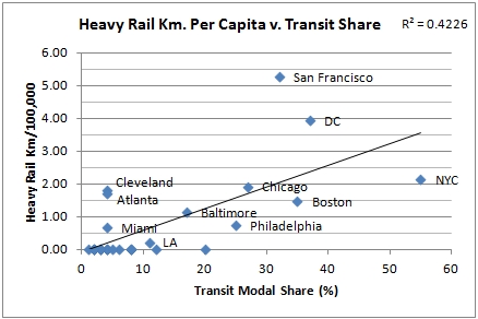
By contrast, the correlation between transit share and kilometers of heavy rail is much more robust.  For this chart, only urban heavy rail systems, such as subways, were included. Regional commuter rail, such as New York's Long Island Railroad or San Diego's Coaster line, is excluded to keep the comparison consistent:


Eliminating the cities with no heavy rail from the sample reduces the correlation to an R2 value of .17.

Last, and perhaps most surprising, are the light rail numbers.  Regardless of whether cities with no light rail are included, there is a statistically insignificant (but consistently negative) correlation between light rail kilometers per capita and transit share.  The United States seems to be flush with cities with substantial light rail networks and low transit modal share.  The exceptions are the cities which also have heavy rail networks (SF, Philadelphia and Boston).  Three other heavy hitters have no light rail, although all had systems in the past (NYC, DC and Chicago):


Two cities with no or essentially no light rail at all, Milwaukee and Detroit, surpass numerous other cities with extensive networks.  Portland's extensive system, more than five times larger than Seattle's on a per capita basis, has only earned it 60 percent of that city's modal share (arguably, Seattle should be given an even lower value on this chart, as the King County branch of its light rail system opened more than halfway through 2009, the year measured by the ACS in computing modal share data).

Are there any further points to glean here?  Certainly no correlation shown here approaches the correlation of urban population density to modal share that I provided in the previous post, which remains by far the strongest correlate of transit use. The role of bus networks is obviously huge, but I wasn't able to find a single metric useful in making cross comparisons that was available for all bus operators (routes per capita is a possibility, but there is no way of knowing the length of these routes in most cases.  I might add it in later anyways, if I can locate the data for it). Commuter rail would introduce more complexities.

Chart data are below.  Numbers in the last three columns show miles and kilometers per capita (per 1,000 or 100,000).  Note that modal share data are for cities, rather than the greater urban areas from which population figures used to compute per capita highway and rail figures are drawn, but are more closely tied to the types of urban transit systems I have included.  You are welcome to reuse this information, but no guarantee of accuracy is offered.  Contact me if you'd like the excel file.

Sources:
DOT: Highway Statistics 2007
2009 ACS via The Transport Politic
Wikipedia (for light and heavy rail statistics)

Related posts: 
Chris Bradford: The association between density and mode of commute. Chris finds that standard density is weakly predictive of transit modal share, but weighted, or perceived, density is strongly correlated with it.
Laurence Aurbach: Fun with Density and Transit Statistics.

Saturday, May 26, 2012

Density and Transit: Some Numbers

Note: Updated 5/29 with an expanded list of cities.  This has slightly weakened each of the correlations.

I've posted on density-related issues several times, including the relationship between height and density, building footprints and density, and street width and density, but I haven't said much about density and transit use.  Cap'n Transit has, though, recently writing a series of posts skeptical of the notion that certain areas "don't have the population density to support transit."

I think the Cap'n is right that this statement, as it's phrased, isn't all that helpful in clarifying the issue.  Instead, in all or virtually all cities, the presence of public transit is a matter of political will – in low-density Arlington, TX, the largest American city without public transportation, only political opposition has stood in the way of the establishment of a bus network. Whether the system would be profitable is presumably only one of several factors in the debate.  Below some point of total population or density, we might be confident in saying the economics would forbid any political consideration of public transportation, but that line is not a bright one.  Private mass transit is more directly tied to profitability, but this in turn is affected by political choices, both toward the private operators themselves and to competing forms of transit (which, as Cap'n has pointed out, includes cars).

A more interesting question, to me, is whether we can say anything more broadly about the relationship between density, both of population and jobs, and transit modal share. The chart I've put together below plots the residential density of a group of the largest American cities, measured by urban area, against commuting transit modal share, using data from the 2009 ACS (raw data is further down):

While there are a few transit overachievers, notably Portland, Seattle, Boston and Washington D.C., the correlation is overall very strong.  No city with an overall density of less than 4,000 per square mile, and there are many, has broken a 10 percent commuting modal share.  The most notable outlier, Miami, may possibly be explained by examining its CBD employment density and job concentration in the charts below.
  
Here is the same exercise, but using the employment density of each city's central business district (in thousands per square mile) in place of residential density:


A similar correlation is there, but it is not quite as strong.  Cities can build equally dense downtown employment districts with almost any level of transit share – cf. Dallas (4), Los Angeles (11), Philadelphia (25) and San Francisco (32).  Again, however, those cities with lower employment densities have difficulty attaining higher mode shares (the cutoff point appears to be around 100,000 jobs per square mi.).


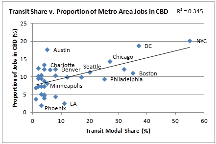
Finally, a comparison substituting employment centralization (proportion of all jobs in the metro area located in the CBD) for employment density:


The correlation is by far the weakest here – a dense, polycentric city can achieve reasonably transit high modal share – but highly monocentric cities appear to have an easier time boosting transit use. Low density monocentric cities fare poorly. (Interestingly, Washington DC, much criticized for the economic effects of its height limit, which has allegedly driven jobs outward to edge cities such as Tyson's Corner, is the second most job-centralized of large American cities. High-rise Dallas and Atlanta, by contrast, are heavily decentralized).

The lesson here seems to be that, when it comes to increasing the share of city residents using transit residential density is a key, if not the key, factor.  It may also increase the financial viability of the transit service, although it is possible that mode share and transit expenses are also closely correlated.  That, and some other possible comparisons, will have to wait for another post. 


Employment data from 2000 Demographia studymode share data from 2009 ACS via The Transport Politic.

Friday, May 4, 2012

Bikes, Transit and Traditional Urbanism

Back in 2010, Nathan Lewis published what is one of the few pro-urban critiques of transportational bicycling available on the net. In the piece, he calls into question the assumption that increasing rates of urban bicycling, or increased provision for bicycle infrastructure, are necessarily beneficial for pedestrian-centric traditional urbanism.

One of the greatest dangers, Nathan writes, is that a city consciously designs itself around the bicycle, while neglecting the needs of people on foot. It is not a groundless concern: the blog Half the Fun critiques (with photos) the Dutch city of Houten, which was designed entirely around bicycles, for having "lost sight of the forest for the trees" by its focus on cycling rather than on "creat[ing] better, more livable communities."

The article concedes that "more bikes on the road would lessen just about every transportation problem you can
A growing storage problem: bicycle parking by a transit
station, Copenhagen (Leif Jørgensen).
think of," but I think that is true only where a new bike trip replaces a trip by car. Replacing a walking trip or a transit trip is less obviously beneficial from a citywide perspective, since the bicycle introduces potential conflicts with pedestrians and presents parking issues that differ only in scale from those of cars. A review of European transportation initiatives, however, shows a frequent focus on increasing bicycle use and modal share, rather than simply decreasing automobile share, with the unstated assumption that the added bicycle riders will be drawn largely or exclusively from the pool of car drivers.*

That may not always be the case. Although evidence isn’t abundant, one study in the Danish city of Odense found that, during the mid to late-1990s, although the share of all trips taken by bicycles rose from 22.5 to 24.6%, this was accompanied by decline in the share of public transportation from 8.2 to 6.6%. By contrast, in Portland, a recent increase in bicycling share appears to have been drawn at least as much from the driving population as from transit riders. This question of whether increased funding for bike infrastructure indirectly results in the decline or stagnation of a city's own transit ridership should be of interest to municipal transportation agencies.

Based on commuting modal share statistics, it is not always easy to tell the extent to which new cycling trips have displaced transit and walking trips, car trips or both. Consider the dramatically different commuting mode shares of four European cities, each of which has taken a somewhat different approach toward transportation, while all having near-identical rates of car commuting:
 
On first glance, it's not easy to explain the differences between cities like Copenhagen and Vienna. Both are national capitals of similarly sized countries with similar metro populations and mass transit networks that include extensive subway systems.  Vienna is denser than Copenhagen, which may in part explain the much higher walking share, but we see that despite Copenhagen's immense pro-cycling efforts (so extensive that they have given their name to a popular pro-bicycling movement), its car share is only slightly less.  Vienna, by contrast, has a much more modest goal of increasing bike share to eight percent, but has primarily focused on improving transit share.

In fact, the results over time for both cities show that transit share hasn't budged, even though Copenhagen's metro entered service in the middle of the time period below (Vienna's U-Bahn has undergone recent expansion but much of the system, which opened in 1976, predates 1993).  Is it possible that pro-cycling efforts siphoned off potential transit riders in Copenhagen?  And if so, was this beneficial for the city?


Vienna street: pedestrian-centric design,
not friendly to bikes (Flickr/PaulLamere)
Vienna met its own earlier cycling share goals, but even more significant was the increase in walking share, which far exceeded expectations even though walking is hardly mentioned in Vienna's 1993 transport agenda.  What Vienna had in abundance, after all, was dense, traditional urbanism the ultimate pedestrian infrastructure.  Through restrictions on cars, the city streets again became pleasant places to be, inducing walking far more than expected.  Copenhagen implemented similar policies, yet saw a decline in its already low walk share. 

Still, it is difficult to be too critical of increased bicycle use.  By the standard of almost any American city, Copenhagen's achievement in reducing modal share for cars is remarkable.  The bicycle, too, is an almost magical technology, the sole transportation method devised by man which has improved on the energy efficiency of walking, and one which expands the range of choices for city dwellers.

But is it enough to consider the impact of bikes on the natural environment? Shouldn't their cumulative impact on the urban environment be considered as well?  This will involve issues not only of parking ever-larger numbers of bikes as their popularity grows, but of compatibility with walking and mass transit, and of a city's vision for the interaction between the various modes of urban transport.

One final mode share chart, for New York:


The cycling share may seem surprisingly low, but consider what a bicycle is worth in the city: although it may improve mobility as compared to walking alone, it also essentially locks the bicyclist out of New York's entire public and private transit system (MTA and taxi service), all of which is implicitly designed around the person on foot (sure, there is the Metrobike and other folding bikes, but their appeal is limited and practical difficulties remain).  With the transit system running 24 hours a day, even the ready availability of the bicycle ceases to be an advantage.

All this suggests that as a city's mass transit system improves its frequency, coverage and hours, the value of a bicycle for urban mobility should decrease until, in the case of New York, it reaches close to zero for many neighborhoods.  There's room for difference of opinion, but I think this must be seen as a good thing.  Bikes can be an excellent transit gap-filler, in limited number, but may not be as well suited to being the central element of a transit strategy.


*See e.g. Copenhagen ("it is municipal policy that cycling mode share should go up to 40% by 2012 and 50% in 2015"); Groningen (city "promot[es] cycling as the main mode of transportation" with "vast expansion of the cycle network"); Charter of Brussels: (cities pledging to "set of target of at least 15% for the share of cycling in the modal split of trips for 2020").

Tuesday, April 10, 2012

Houston's Own Equitable Building: The Political Perils of Building Tall

If you were a developer operating in a city without zoning or height limits and, for whatever reason, wanted to devise a project sure to turn the local population in favor of development restrictions, what might you do?

Historically, a winning strategy has been to build structures of unusual height in lower-rise areas: New York's Equitable Building, completed in 1915, stirred public controversy with its bulky 38 stories and contributed to the adoption of the setback provisions in the city zoning ordinance adopted only a year later.  A similar story could be told in Paris, where the completion of the notorious Tour Montparnasse led the city to ban the construction of skyscrapers in the city center. Washington D.C.'s Cairo apartment, at a modest 12 stories, stoked a wave of 19th century NIMBY sentiment that culminated in the still-extant Height of Buildings Act.  Mexico City has recently witnessed a similar controversy.

With those examples in mind, I've been reading about the multi-year efforts of a Houston developer to construct a 21-story residential tower adjacent to a well-to-do and politically active neighborhood of owner-occupied single family detached homes some distance from the city's central business district.  Unless the developers were exceptionally naive, they might have foreseen the result: a grassroots neighborhood campaign to oppose the project, accompanied with a cartoon drawing of a high-rise tower with fangs and an evil stare menacing neighborhood homes.

Faced with a city reluctant to accept its plans for the tower in the face of public opposition, the developers, rather than altering their plans, sued the city, further angering neighborhood residents.  The developer ultimately prevailed in a settlement reached in February, but while the battle was won, the war may have already been lost.  In late December, the Houston city council adopted an ordinance specifying that buildings over 75 feet must be buffered from surrounding properties with large setbacks, and that a "10-foot landscape, trees and an eight-foot-tall fence" are necessary where surrounding properties are residential homes.

Even so, many residents were apparently dissatisfied with the law, raising the question of whether there may be additional political fallout.  As one commenter on the Houston blog Swamplot put it:
"The short term result is that the developers get to build their highrise. The long term result is that several hundred of Houston's wealthiest and best connected residents are now more likely to support zoning and candidates who are for zoning."
Considering that the entire city of Houston appears, according the Council on Tall Buildings, to have only around 20-30 residential buildings of over 20 stories, the story of the Ashby high rise really wasn't that long in coming. 

In this drama, the developer and the neighborhood are merely reenacting a play that has been staged many times since the late 1800s, and almost always with the same ending.  It is the rare lax regulatory environment that has survived the construction of high-rise apartments in "detached house sections," to borrow a phrase from Euclid v. Ambler author Justice George Sutherland. The economic attraction of high-rise apartment builders to affluent, low-density residential areas has often been politically fatal, with developers proving themselves to be their own worst enemies.

The greater danger for a city is that the construction of a single tower drives a furious political backlash against development that eliminates the possibility of even moderate density and mid-rise residential construction, even where that more modest development might have been unobjectionable on its own. Although Houston doesn't appear to be in immediate peril of this outcome, the precedent of height-based restrictions has been set in a city which formerly had none.

The politics of tall buildings also complicate the suggestions of some, like Ed Glaeser, who advocate building up in low and mid-rise urban areas.  Height restrictions in Paris are in force precisely because of prior attempts to build tall, rather than ignorance about the economic principles of supply and demand.

The emergence of form-based codes offers one potential solution through providing the advantage of reliable expectations for both developers and neighborhoods, but for cities looking to densify there may be no easy answer to what seems to be an intractable political challenge.


Monday, March 19, 2012

Can Loosening Development Restrictions Restore Affordability?

It seems that market-based approaches to increasing housing affordability are at last getting widespread attention.  Between Ed Glaeser's Triumph of the City and Matt Yglesias' The Rent is Too Damn High, a long-overdue conversation about the impact of land use regulations on the cost of housing is finally happening.

As an ally of those calling for an end to such policies as rent control and overly restrictive zoning, I hesitate to throw a bucket of cold water on these affordability strategies.  They certainly would, over time, have a positive impact on housing supply.  Whether New York can build its way up to affordability, though, is a more debatable question.

A basic point I'd raise is that in almost all times and places, the solution for urban population growth has not been vertical densification, but outwards expansion into greenfield areas.  Historically, dramatic vertical growth was the product of exceptional circumstances, generally related to the presence of city walls paired with external military threats discouraging sub-urban construction, or the occasional imperial mega-city.  The development of skyscrapers in the late 19th century looked to have the potential alter this longstanding pattern, but for several reasons, greenfield development still remains today the overwhelming source of accommodation for urban population growth:
  • The naturally slow pace of incremental infill development in a built-up area. Even where demand is very high, the process of acquiring parcels from a multitude of private owners, demolishing structures, and rebuilding, is slow and arduous in the best of times.  The technological possibility of skyscrapers themselves may inflate land values, resulting in speculative holding that further deters redevelopment.
  • The opportunity cost of densification. Existing buildings, even of very low value, still represent a sunk cost now generating a reliable stream of income for a current or prospective owner.  The new building must not only justify itself on its own terms, but justify itself in relation to the profits being earned on the existing building, less the time lost to construction. 
  • Political opposition.  It may be condemned as unfair, inefficient or narrow-minded, but as long as there are people living in neighborhoods, there will be people willing to oppose new and denser development in those same neighborhoods.  That doesn't mean strategies to reduce neighborhood opposition to densification or to encourage infill shouldn't be pursued, but it does mean that, all else being equal, greenfield development will almost always present fewer political obstacles.
These factors help explain why New York City increased 2.1% in population from 2000 to 2010, while San Antonio increased by 16.2%, or Charlotte 32.2%.  The claim of Joel Kotkin and Wendell Cox that census figures show growth primarily in "the suburbs" is little more than a truism.  Growth simply occurs where there is room to grow on a clean slate, whether that growth is in high-density or low-density form.

San Antonio and Charlotte, as sprawling as they are, have distant greenfield margins. New York's dense core, by contrast, is surrounded by geographic boundaries and vast areas of very low-density residential spreading far north into Westchester and Fairfield Counties, and west into New Jersey.  Houston proper, even in the absence of zoning, only experienced a 7.5% population increase within its largely built-out limits, even as its MSA grew by over 26%. 

Were zoning abolished, rent control repealed, and developers given free rein in New York, could growth rates remotely comparable to sunbelt cities possibly be matched?  Not likely.  Even equaling Houston's growth rate – a city with abundant vacant land in and around its downtown – would probably be a challenge.  Affordability is an even more distant goal using supply-based strategies alone.  Relaxing development restrictions that worsen affordability and hinder supply is a crucial goal, but not one which is likely to lead to rapid population increases, or housing cost relief, in built-out and geographically-constrained cities.

Related posts:
Can New York Build Its Way Up to Affordability?