Friday, November 11, 2011

A Walk Through Occupied NY

Update 11/15: As you've read by now, the settlement shown here was removed last night by the NYPD at the order of the mayor, who was quoted only a week ago stating his lack of objection to the new, higher quality tents that had begun arriving (see end of post).  Since the protestors apparently are barred from setting up new tents, it looks as though this will be the first and last post on this intriguing subject.

With the Washington Post running an article on the "do-it-yourself urbanism" of Occupy D.C.'s encampment, and Steve Stofka observing the emergent patterns evident in Occupy Philadelphia, I decided yesterday to hop on the Lexington Avenue Line down to the Fulton Street stop, just a block or so away from Zuccotti Park, the site of Occupy Wall Street, to see this nearly two-month old settlement up close.  I wasn't alone: a number of foreign tourists, maps and cameras in hand, were also gathered around what has apparently become a major attraction of Lower Manhattan.

Although some earlier photos I'd seen gave the impression of a scattering of tents, tables and ad-hoc meeting places, the park has evolved quickly into a very dense settlement with almost every square foot put to use, a consequence, in part, of the limited space within the granite-walled boundaries of the park, an infill process mimicking the growth of cities within medieval fortifications:


The path at right is the "Main Street" of the settlement, now lined with a mix of the tables of various groups and organizations, from anarchists to pacifists, as well as a large cafeteria, a library, and even some retailers with large, walk-in tents:


The path is generally six feet wide, broadening to eight or so in places.  No one brings in so much as a bike. The "residential" streets, running off this central way, are even narrower, some a couple feet wide, others leaving just enough space to step between the tents:

The police, as far as I could tell, stayed out of the settlement entirely, keeping to the sidewalks around the periphery.  Nor has there been a sign, at least since last month, of any imminent plans for eviction from either the city or the owner of the park (which is by law required to be open to the public round the clock).  The official stance, it is rumored, is to wait for winter cold to disperse the protestors. 

This assumes that the settlement has no capacity to adapt or improve from the current mish-mash of tarps and L.L. Bean summer camping tents  but is this place more analogous to a Soweto or a Rocinha?  I didn't distinctly notice it during my walkthrough, but the photos show the evidence: look closely at the top left of the first photo and you'll notice a pair of large green tents, the first of many scheduled to arrive shortly, and which have been cleared with the city:

"[The OWS members'] newest plan to install 27 military-grade tents designed to stave off freezing temperatures and precipitation, which they began to bring to reality Tuesday, is kosher with the city, Bloomberg said during a Q&A session after an unrelated press conference in Hell's Kitchen Monday."
For a supposedly rudderless movement, "OWS" seems to have set things in rapid motion at Zuccotti Park, although there would be some irony in the settlement coming to outwardly resemble a military barracks.  I'll need to check back in a week or two to see how things have changed, but by the looks of things no one's going anywhere anytime soon.

One last thing: population density.  As best I can tell, for this settlement, it is approximately 150,000 per square mile.

Monday, November 7, 2011

Nathan Lewis on "Stuff that Works," and New Narrow Streets Advocates

Nathan's latest, Let's Take a Traditional City Break 5: Stuff that Works, is now available on his site; In it he features a new development in Burlington, Ontario, mentioned here by commenter Nicolas, which has adopted a genuinely traditionalist design format. Nathan also mentions a promising new site, SmallStreets.org, which as far as I know is the only narrow streets advocacy organization out there. Is the movement gaining steam? Nathan's writings are cited as an inspiration for its creators, but they've very kindly linked to this blog as well. Check them out – there's a lot of great material on there so far, and I'm sure more will continue to be added.

Umbrian street at right.

Wednesday, November 2, 2011

Park Economics

What's an urban park worth to a city?  The question is straightforward, but despite the attention lavished on parks in the urban design literature, the economics of parks their measurable costs and benefits have received less attention.  Although "the science of city park economics is still in its infancy," according to the Trust for Public Land, a number of studies over the past decade have helped establish a consensus on a few key points.

Attempts to determine the value added by parks date at least back to the 1860s, when Frederick Law Olmsted attempted to calculate the increase in Manhattan real estate values generated by the creation of Central Park.  That the park increased the value of the land adjacent to it was obvious, but Olmsted might have considered several other key questions, such as:
  • Even if a park increases values, do those increases outweigh the the value that would have been gained from leaving the land available for development?
  • Alternatively, could the same or approximately similar increases in value be achieved with a reduction in park acreage (and thus an increase in developable land)?
  • Are values better served by a small number of large parks or many small parks, bearing in mind that many small parks are more expensive to maintain than a few large ones?
  • Do certain types of park programming and design increase values more than others?
A growing literature has begun to provide answers to these questions.   The Trust for Public Land has put together an accounting of the potential benefits of parkland, which, however, does not consider the countervailing costs of maintenance and land lost to development.  Other writers have made more questionable arguments. Among these is the one that revenue-positive parks are an economically desirable option in comparison to money-losing single use residential development, a point which is not so much in favor of parks as it is an illustration of the financial unsustainability of contemporary development patterns.

One of the best resources on the topic is a 2001 MIT Department of Architecture thesis, which was guided by several urbanist eminences including AndrĂ©s Duany and Eran Ben-Joseph.  Although I'd encourage you to check out this paper on your own, some of the author's most important findings include:
  • Homes adjacent to parkland receive a 22% price premium, but the premium rapidly drops off for properties beyond 600 feet from the park.
  • Large parks do confer greater premiums than small parks, but the premium is small compared to the effect of being close to a small park.
  • Smaller lots place a higher value on park proximity than large lots.
In light of these findings, the author recommends a series of small parks, rather than a handful of large parks, as the property value benefits of the former will typically exceed the maintenance savings of the latter. 

The intended use of a park also has a large impact on the effect the park will have on surrounding properties, according to the Trust for Public Land.  Space devoted exclusively to athletics, for instance, may actually harm adjacent property values; open space designed as a wildlife corridor or for stormwater runoff can also be a disamenity where an unlit and forested area is perceived to pose safety issues.  Large parks may also suffer from safety issues resulting from lack of use.  Certain common purposes for open space, therefore, may not coincide with the objective of improving surrounding property values.

None of this, I think, would come as a surprise to Jane Jacobs, who through personal observation and study reached many of the same conclusions:
"Conventionally, neighbourhood parks or parklike open spaces are considered boons conferred on the deprived populations of cities.  Let us turn this thought around, and consider city parks deprived places that need the boon of life and appreciation conferred upon them.  This is more nearly in accord with reality, for people do confer use on parks and make them successes – or else withhold use and doom parks to rejection and failure."
Even more to the point:
"City districts with relatively large amounts of generalized park ... seldom develop intense community focus on a park and intense love for it. ... Parks intensely used in generalized public-yard fashion tend to have four elements in their design which I shall call intricacy, centering, sun and enclosure."
Jacobs, in Death and Life of Great American Cities, was reacting the common tendency of planners in her era to dedicate excessive amounts of land for open space, such that the space became an obvious disamenity, and a liability, rather than a benefit.  Planning decisions about parks are going to revolve around more than the mathematical calculations of a developer, but having the tools to think about parks in a more objective way can aid in the creation of parks that are both successful and financially beneficial.

Friday, October 28, 2011

Friday Read: Fogelson on Restrictive Covenants

Although Robert Fogelson's Downtown: Its Rise and Fall is his best known work, the 2005 follow-up Bourgeois Nightmares, the title a play on Robert Fishman's 1989 book is a quick read which provides, so far as I know, the only book-length history of restrictive covenants in the United States.

Although race restrictions seem to be the focus of most studies in this area, Fogelson looks at other aspects of this history as well, examining how courts reacted to the imposition of use-based restrictions in the late 1800s, and how the public's conception of property rights came to be transformed over this period in ways which have remained more or less unchanged down to the present day. 

One of the more interesting points I thought was Fogelson's explanation as I've argued here before in the context of zoning that the main purpose of the restrictions was not to increase property values, but ultimately to constrain them:
"The suburbanites were confident that most people would refuse to sell to an African- or Asian-American or other "undesirable" person even if offered a very high price. ... But the suburbanites were far from confident that most people would turn down a good offer from a desirable person, a well-to-do white Christian like themselves, who intended to use the property for an undesirable purpose. They were afraid that most people who owned a corner lot would sell to a builder who wanted to erect an apartment house (or, even worse, open a store, saloon or gas station) and was ready to offer five or ten times what the lot was worth as the site for a single family home. ... They were afraid that was what most people would do because they knew that if they found themselves in the same position that was what they would do." p. 143.
The early 20th century restricted suburb was, as Fogelson shows, the result of a process of elimination as much as it was a positive vision: an elimination of "undesirables," a group which could comprise over 95% of the population, an elimination of commercial uses, of attached houses, of multi-family residential buildings, of houses too close the front property line, or too close to the sides, of houses that were too big, or too small, or too ugly, or too cheap, an elimination of fences, of farm animals, and even of household pets.  Above all, there was a fear of market forces, and an inability to conceive of change and urbanization in anything other than apocalyptic terms. 

From the residents' perspective, the scenario that Fogelson describes was essentially perceived as a market failure. Although the seller might reap a windfall, the thinking went, the remaining residents believed that the arrival of a saloon heralded the beginning of the end of their way of life, and would send homeowners stampeding for the exits.  That this was a self-fulfilling prophecy didn't render its effects any less real.

Although Fogelson observes that it was often fear that gave rise to these restrictive covenants, it's worth noting that their existence was not necessarily incompatible with a dense residential environment.  Boston's Back Bay, as Fogelson describes, was deliberately planned as an urban domain for the well-to-do, and was subject to numerous use-based restrictions from the outset. Giving up a degree of urban flexibility in order to retain, at fairly high density, high-income residents who might otherwise have fled to the suburbs apparently seemed a reasonable trade to Boston's Public Land Commissioners. 

In spite of this success, the Back Bay, as a literal infill project, was unusual in that it provided a blank slate close to the city center.  In general, late 19th and early 20th century America produced very few examples of compelling urban environments for the wealthy.  The Back Bay was one.  New York's Upper East Side was another.  Apart from those, and a handful of others, there was little to curb the flight of large numbers moneyed citizens out of cities and into restricted suburban communities.  A belated realization of the harm done to cities by this emigration occurred decades later and played into urban renewal schemes for the demolition of downtown working class neighborhoods, but that part of the story is beyond the scope of Fogelson's book.

At some point I'll have some additional thoughts on Fogelson's magnum opus, Downtown, but if you've been through that one and haven't yet discovered Bourgeois Nightmares, it’s a quick read that's worth your time.

Monday, October 24, 2011

A Hope VI Gallery

In the comments to last Monday's post, several commenters suggested that the example I'd chosen, J. Henry Hale Homes in Nashville, was not representative of the design quality of many Hope VI projects.  For the sake of balance, I've put together a series of aerial and street-level images of each of several projects chosen from a variety of locations.  Rather than editorializing, I present them accompanied by a short statement from their planners or from other relevant sources to let you judge for yourself the merits or shortcomings of each of the projects (click on the images to enlarge):

Bedford Hills Apartments, Pittsburgh

"Through the community-driven design process, the planners learned of the residents’ interest in maintaining the look of the existing housing stock. It was important that the new units fit in the context of the neighborhood. Consequently, the design team spent much of its time in the surrounding neighborhood documenting existing housing types and architectural styles. ... Each rowhouse, including the rental townhouse flat units, has a front door that opens up onto the street, providing residents a sense of ownership and a direct connection to the community. ... Resident surface parking lots, accessible by driveways, were situated in the rear of the housing units. Small setbacks of the houses enabled the planners to incorporate landscaping into the plan." -Project Summary
Broadway Overlook, Baltimore


"The final master plan for the Broadway Overlook was more human in scale than the former Broadway Homes and oriented to pedestrians instead of automobiles. Parking is either on-street or in the rear of the units. Not all of the units have dedicated parking, but the steep topography of the site made it possible to place some of the resident parking beneath the new units, to be accessed from the rear. Although the master plan worked with the existing street grid, it incorporated two new streets to facilitate greater density.  These streets were designed to be one-way with on-street parking to help buffer pedestrians from direct traffic flow, therefore making it a more pleasant and safe streetcrossing experience. Like the surrounding community, the townhomes borrow from the Federal and Italianate architectural styles and consist of single-family and two-family dwellings that range in height from two to four stories." -Project Summary

Centennial Place, Atlanta

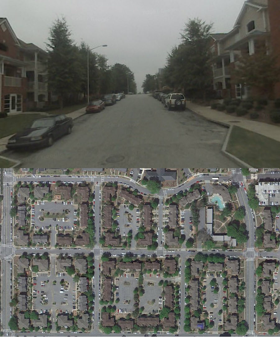
"Over 900 families live in new garden apartments and townhomes. Some families make a few thousand dollars a year and some make more than $150,000. But you won’t know which by looking at their housing units. They live side by side in an attractive neighborhood of tree-lined streets. Two swimming pools and a fitness center in the development, and a new YMCA nearby, provide recreational opportunities. New commercial development is underway – being built with private investment." -Development Description


Flag House Courts, Baltimore

"Torti Gallas and Partners responded to the special challenges of this revitalization project with sensitive solutions. Rental, homeownership, and live-work units are designed with a consistent esthetic treatment that dissolves the stereotypes surrounding public housing. Housing density is reduced, allowing the introduction of planned open spaces. Blighted structures are demolished to create a rejuvenated environment. Safety and security are intrinsically planned into the neighborhood, and units are designed so that living areas face streets and public spaces. Creative plans fit comfortable units within the existing narrow lot widths." -Project Summary

High Point, Seattle

"By the end of the decade, High Point will have nearly 1,700 new affordable and market-rate units across its 120 acres. Most homes will have private yards and porches. They will sit on safe streets with controlled traffic, and will show great variety in architecture, with character and styles on each block. ... To maintain the green, garden-like feel, the plan designated over 20 acres of land for parks, open spaces, and playgrounds. A four-acre, central park will be at the heart of the community. Another park features a large pond and a jogging trail, and several other community and pocket parks are scattered throughout High Point.  Even planting strips along streets will be greener and wider than elsewhere in Seattle. The plan triples the number of previously existing trees." -Redevelopment Plan

Martin Luther King Plaza, Philadelphia

"Significantly, new housing is equally divided between on-site reconstruction and off-site renovation and infill. Long term sustainability of the reconstructed project will be assured by eliminating blight and creating stability in the broader community.

One key to the on-site master plan is the creation of a new residential square founded in the tradition of neighborhood-making established by William Penn, founder of Philadelphia. This new open space will be a focus for the broader Hawthorne neighborhood and will marry new and renovated housing, retail with residential above, and a host of local institutions, including a new daycare and community center, a local church and an existing elementary school. The architecture of the new units includes a diverse set of types modeled on traditional patterns of Philadelphia neighborhoods." -Project Summary

Mechanicsville Commons, Knoxville

Existing houses in the neighborhood reflect the architectural styles that were popular in that era, primarily Victorian cottages and Craftsman bungalows. The house designs created for Mechanicsville Commons and for infill in the adjacent neighborhood respect these architectural traditions, incorporating elements from them – deep front porches, Victorian fretwork, and Craftsman brackets – to enrich the facades. The houses are painted in rich colors that give distinct personality to each house and create a lively streetscape. -Architect's Summary                      "As a minimum requirement, all new residential structures should have seeded lawns around the entire house and foundation plantings along their front facades. Landscape plantings and treatment help to define the mood for the residence as well as that of the entire neighborhood. ... In addition to the general landscape guidelines, one small ornamental tree shall be planted in the front yard; a minimum of one large ornamental or canopy tree shall be planted elsewhere on the lot." -Design Guidelines

New Columbia, Portland
The vision for New Columbia was to create a vibrant new neighborhood with a mix of housing types affordable to people at all income levels. New Columbia includes the following features: A mix of residents, representing a variety of cultures, age groups, and income levels; A community-friendly design, with front porches, parks and public spaces; A new street grid that provides easy circulation within New Columbia and connects the community to the rest of the Portsmouth neighborhood; A Main Street that offers a variety of recreational, cultural and educational opportunities both for New Columbia residents and the surrounding neighborhood. -New Columbia website

"A sustainable stormwater management system retains 98 percent of stormwater onsite, treating and infiltrating water into the ground, avoiding piping overflows into local waterways. The system includes 101 pocket swales (or as residents call them, “rain gardens”), 31 flow-through planter boxes, and 40 public infiltration dry wells." -New Columbia website

"Portland doesn't really have food deserts ... . But it has patches such as New Columbia, a community of 3,000 mostly low-income residents where people must travel long distances to get to groceries." -Portland Tribune, March 10, 2011

North Beach Place, San Francisco

"North Beach Place is one of the largest mixed income, mixed-use complexes in California, comprising a 341-unit development; 20,000 square feet of commercial space, including 3,000 square feet of incubator space for resident entrepreneurs; and a childcare/community center. Located in San Francisco’s popular North Beach area, with proximity to both transportation and employment, this complex is a model for transit-oriented urban infill developments.  ..." -Builder's Summary                     

"PGA’s green roof concept allows for underground parking, street-level shops and 341 apartments interwoven with inviting outdoor spaces, including courtyards, gardens, seating areas and six childrens’ play areas, all designed to enhance urban life. PGA was also responsible for the design of surrounding urban streetscapes." -Landscape Architect Summary


Renaissance Place at Grand, St. Louis


The developer's website does not describe the design approach.  However, this project recently won LEED-ND certification:


"Renaissance Place at Grand neighborhood was recently Certified in the U.S. Green Building Council LEED for Neighborhood Development (LEED-ND) Pilot program.  Renaissance Place received outstanding LEED-ND scores in the areas of “Smart Location & Linkages” and “Neighborhood Pattern & Design” rising from its connections to amenities in the surrounding community—a variety of retail stores, cultural institutions, schools and recreational options—all accessible within a ½ mile walking distance or convenient Metro transit lines. Renaissance Place also met its “Green Construction and Technology” targets by using environmentally sensitive construction techniques and by ensuring that brownfield contamination, storm water runoff and pollution from construction activities were significantly reduced or completely abated. The site also avoided environmental disruptions by using pre-existing water and wastewater infrastructure, restoring the historic street grid and using a dense design that helps to minimize unnecessary land use."

Thursday, October 20, 2011

Debating Height in Washington Heights

The New York Times recently ran a story on a developer's ongoing efforts to construct several high-rise apartment buildings in the characteristically mid-rise Washington Heights neighborhood.  While much of the article focuses on concerns about gentrification, the zoning angle is equally noteworthy:

"Local residents call the neighborhood the Heights because of its steep terrain and riverside bluffs, not because it has vertigo-inducing buildings.

So a developer’s plan to build four apartment towers ranging from 23 to 39 stories tall has set off alarms in Washington Heights, where buildings typically run 6 to 10 stories. Some residents have protested that the proposed towers, with a total of more than 800 apartments, would darken the sky and introduce more residents than the area’s schools and subways could accommodate.

Last month, the local community board unanimously rejected a proposal for the four towers, which would have required a zoning change by the city, and it urged the developer, Quadriad Realty Partners, to return with a scaled-down blueprint for shorter buildings at the site, at Broadway and 190th Street. ... Despite the community board’s opposition, the developer said it planned to apply to the city’s Planning Commission for a zoning modification in the next few weeks. But if the change is not granted, the firm says it will then build two stouter, market-rate buildings, 28 and 24 stories tall, which it has the legal right to do under existing zoning."
Below is an image of a typical area of this neighborhood, showing an abundance of "new law" apartment buildings with an approximate ground coverage of only around 55 percent, accounting for streets (40 percent) and space between buildings (5 percent).  Even so, the neighborhood is very dense: approximately 130,000 people per square mile, according to the 2000 census.


My question is: what exactly is the purpose of New York's zoning law here?  Do height limits (or FAR limits, as they may be) in the neighborhood reflect a judgment as to adequate light and air, and to population density?  If so, there can be no justification for bargaining with the developer to raise them, any more than it would have made sense to bargain over the setbacks in the 1916 Zoning Resolution.  If the city is open to negotiation, on the other hand, is the limit simply an arbitrary cap designed to trigger review by the planning commission?  And how does the possibility of negotiation affect land values and development?

In an article from 18 years ago, but still relevant today, Peter Salins writes:
"All these changes [to New York's zoning code] have moved the city increasingly toward a regime of discretionary review, in which city planners must review and approve the way a developer uses the options and exceptions that have been added to the original code. Much of this discretion is used to grant developers zoning concessions in exchange for specific public amenities: not just plazas and arcades, but expensive benefits such as subway improvements, theaters, and low-cost housing. This “zoning for sale” is a game only a handful of well-funded developers, flanked by costly lobbyists, lawyers, and expediters, can play. The benefits to the city are questionable: There is no economic test of the costs or benefits of such trade-offs, and the practice distorts the price of land by encouraging speculation based on the possibility of negotiating zoning concessions at some later date. Moreover, for the city to make such trades suggests that the supposedly critical goals of zoning are not really important, since they can be waived for a price.

The quest to custom-tailor land-use regulations is an endless one. Even as the zoning ordinance has grown increasingly complex, it can never quite custom-tailor enough, so planners must give themselves discretion to approve or reject particular projects on a case-by-case basis. Zoning, which was meant to foster orderly and predictable development, has instead become a chaotic, capricious process that deters the development and renewal of the city."
The point being made here is that if investment is desired, consistency and predictability are virtues.  One of the potential purposes of height limits, in an age where skyscrapers are a technological possibility, is as a check against speculation in land.  For the limits to serve that purpose, they must be absolute, and not subject to waiver or variance, or else they risk becoming a cause of speculation themselves.  Endowing community boards with discretionary veto power adds further complexity and uncertainty to the process.

If the neighborhood believes that ten stories is appropriate, then every proposal for a tall building is doomed to follow the same convoluted process of community hearings, disapprovals, appeals, further hearings, etc., all to end back at the "as of right" allowance, and all squandering a great deal of time, money and goodwill.  Those who wish to avoid controversy by constructing a ten-story building, on the other hand, will find many holdout buyers pricing their parcels for much taller buildings, and development will stall.

On his blog, Alon Levy has recently been advocating a consensus-based approach to planning.  If the Washington Heights neighborhood collectively supports new mid-rise development, could a straightforward height restriction, along the lines supported by the community, be a preferable, and achievable, substitute for the current system?  Libertarian-leaning urbanists are fond of criticizing height limits, but such a limit, in this case, could hardly be more unfriendly to new development than the system that the Times and Salins describe.

Related posts: Can New York Build Its Way Up to Affordability?

Monday, October 17, 2011

Hope VI and Public Housing: The More Things Change...

Stephen Smith has posted a perceptive article critiquing the design of contemporary public housing projects.  The story of public housing over the last 20 years is largely the story of the Hope VI program, which was adopted by Congress in the early 1990s to provide a source of federal funding for rehabilitating, and even more so demolishing and rebuilding, distressed public housing.  Accompanying the new funding initiative was a new design philosophy: HUD secretary Henry Cisneros embraced the principles of the Charter of the New Urbanism the mid 1990s, reflecting a change in course from the tower-in-the-park design principles which had prevailed for many decades. 

This was not an empty gesture, as a vaguely New Urbanist design approach came to be reflected in dozens of Hope VI projects built over the ensuing fifteen years.  But just how new was this approach, really?  A close examination of justifications given for the projects themselves reveals certain overriding concerns, which for those familiar with the history of urban planning in the 20th century may seem familiar, but which have little do with New Urbanist principles.

A concrete example might help illustrate the point.  The project I'm most familiar with is the recent Hope VI redevelopment of Nashville's J. Henry Hale Homes, a project that was typical of the low-rise public housing constructed in Nashville during the 1950s.  Although the original project was demolished around 2006, Google earth shows it as it existed before:


The buildings shown are all two-story structures.  The planning principles at work in creating such a development were perhaps not as careless and insensitive as they're sometimes made out to be:
"...[W]ith houses and gardens in compact groups ... there can be playgrounds for different age-groups and parks and perhaps even a community center, instead of dead chasms between houses and acres of unnecessary pavement in streets, sidewalks and alleys. The whole neighborhood may be just one super-block, which means complete play safety for the children and clean, quiet green surroundings and outlook for all the houses. For access to the houses there may be small dead-end streets. Garages and parking spaces are conveniently located at the nearby street-front. The house itself, shallow and never more than two rooms deep, has sun in every room and far more real privacy than an 'individual' house on a narrow lot."    -Catherine Bauer, A Citizen's Guide to Public Housing (1940).
This is hardly traditional urbanism, but there is a clear acknowledgement here of the problems of welcoming the automobile into the heart of a residential environment, as well as a backlash against the repetitive, amenity-poor process of speculative lot subdivision that had characterized the seven decades or so preceding 1940.  The development relegates the handful of parking lots in groups to the fringes of the development, or to dead-end access ways.  The few auto streets are quite narrow and naturally control speed with T-intersections and sharp turns.  Far more numerous are the narrow pedestrian paths linking the housing units to the streets and to the two large park areas within the project.  Overall, it is a pedestrian-focused environment, with a balance of built space, streets and park space reminiscent of a college campus. 

For reasons that have been hotly debated, this project, like many others, quickly degenerated into a focal point for crime and poverty. Was it the fault of its design?  Nashville's director of the Metro Development and Housing Agency, Phil Ryan, thinks so:

“Part of the problem with public housing in the U.S. is overly dense housing that’s unappealing and unattractive,” Ryan explained. “The extreme density has created a bad environment for people. ... We think a beautiful mixed-income neighborhood is a net gain for low-income people versus an overly dense, traditional 60-year-old housing development,” Ryan said.
Does this sound at all familiar to the claims of the early 20th century Progressive housing reformers?  It's a position Jacob Riis would have applauded, and which Lewis Mumford might have endorsed.  The key elements might be summarized as environmental determinism, or belief that one's built surroundings influence social behavior, and out of that thinking a belief that decongestion, or a dispersal of population, is the best means of positively influencing behavior -- among a certain segment of the population anyways.  (At least, the Nashville planners, to my knowledge, have never criticized nearby high-end condominium developments for being "overly dense.")   These are not mere idle words, on this project (see below) or others, as a net loss of housing units is characteristic of the entire Hope VI program.

In any event, here is the new project, developed with $20 million in federal Hope VI funding:


A comparison of the projects reveals the following changes:


Is $20 million dollars for a loss of 255 housing units a good use of taxpayer money, one could ask, even if the new units are of higher quality?   Long-term maintenance liabilities have presumably increased as well, with the total paved surface increasing from 7% to 30% to serve less than half the number of units.  And of the new street grid, that presumably New Urbanist-inspired addition?  Does this automobile connectivity serve any purpose in the absence of the mixed uses that New Urbanism advocates but which are absent here, or have Catherine Bauer's "acres of unnecessary pavement" simply reappeared?

The streets have been dramatically widened, flattened and straightened, as well, which has necessitated the placement of speed bumps throughout the project:


And although an article touting the project refers to it as "a neighborhood with real front and backyards, green space and duplex homes," not only has green space been reduced and identifiable parks nearly eliminated, the homes do not, in fact, have backyards:


Front yards do exist, though, with thoughtfully-located utility boxes.  Brick is reserved only for the facades, or rather parts of the facades:


I'll let the reader compare the design and aesthetics of these homes to those of the nearby Andrew Jackson Courts, public housing built some 15 years before the original J. Henry Hale homes:


With this design-focused analysis I won't delve into the city's motives, why it might have wanted to dramatically reduce density in existing public housing projects, or whether the city planners truthfully believed their own pronouncements on density.  The project did "succeed" at largely replacing the population in the project, and there is evidence that tenant management, one the key elements of the relative success of New York's public housing, is now given greater attention. 

From a planning perspective, though, is it possible to argue that this new design approach is always an improvement over the public housing of the 1950s?  Even some of the most sensitively-designed developments replacing notorious projects, such as the redevelopment of the Robert Taylor Homes in Chicago, show a similar emphasis on wide streets, low building footprints, large parking areas and residual "green space."  Perhaps the design philosophy underlying these redevelopments has not changed quite as much as one might think.